Sunday, December 17, 2023

Tail of the Cock Traced on a Rock

On the side of a busy highway near the Ulster County city of Kingston is an series of outcrops quite well known to local geologists. They are along Route 199 just west of the Kingston-Rhinecliff Bridge. 

One part of these outcrops is composed of the Esopus Shale Formation and, in this location, it's dipping steeply to the east with a nice glacially-polished surface making for treacherous climbing onto it (especially since you'd slide down into a massive thornbush if you lost your footing).


Looking at this nice polished surface, you'll see some swirling patterns etched into the rock (there's a little iron staining from what looks like the weathering of small inclusions of pyrite - FeS2).

They reminded some of "rooster tails" leading to their common name.

A close-up shows the pattern a little better.

So what are these? Let's start with a little background first.

While paleontology is the study of ancient life (as preserved in fossils), ichnology is a branch of paleontology concerned with trace fossils - fossils that represent some trace of the ancient organism's activity. An example might be a dinosaur trackway (or the eurypterid trackway I wrote about a couple of weeks ago).

Sometimes all we have preserved from an organism is a trace fossil and we're not even sure exactly what species of animal made the trace. These trace fossils may be given taxonomic names and known as ichnospecies.

This swirly fossil in the Esopus Shale (it's found in some other units as well) is such an ichnofossil and was was given the ichnospecies name Zoophycos caudagalli where caudagalli means “tail of the cock” or "rooster tail".

The name Zoophycos was originally used to describe what was believed to be a new genus of algae (1855). It was later recognized that it wasn't algae at all but rather the trace of a marine worm - exactly what species of worm and exactly what this worm was doing is up for interpretation (although we can make some educated guesses).

Underlying the Esopus Shale, and just east of this particular outcrop on Route 199, are a series of limestone formations, chock full of marine invertebrate fossils, which formed in the early Devonian Period ( a hair over 400 million years ago). These limestones formed in the ancient Helderberg Sea - a shallow subtropical sea which once covered Ulster County (and beyond). Why subtropical? It's because this area was still in the Southern Hemisphere and closer to the equator than we are today.

This once clear sea began to get muddy, however, as mountain building started to occur to the east. This was the start of the formation of the Himalayan-scale Acadian Mountains. That's a story for a different day but suffice to say that the start of this mountain building brought a lot of sediments into the Helderberg Sea making it more muddy and leading to the deposition of the Esopus Shale. The previously-abundant marine invertebrates we see in the limestones disappeared as they were mostly filter feeders, straining organic material from the water, and those types of animals don't do well in muddy bottom waters.

Marine worms, however, do just fine in the bottom muds, as they churn through and extract organics from the sediments. While worms, and soft-squishy things in general, rarely preserve as fossils, they can leave traces of their activity. For Zoophycos, it's generally believed that the swirls were feeding traces of the worm (called spreiten) that lived in a vertical shaft, or burrow, beneath the traces.

Zoophycos fossil photo from the Kentucky Geological Survey

Zoophycos fossils have been found throughout the geologic record from 541 million years ago to modern times and even recent studies (Zhang, et al., 2015) acknowledge that we're still not sure of the exact group of marine worm (sipunculida, echiurida, or polychaeta) that may have made these fossils. Whichever one it was, it certainly hit upon a very successful strategy for existing in the muddy seafloor sediments for hundreds of millions of years.

Maybe my students don't feel the same, but I am always humbled when standing on such outcrops, ignoring the modern traffic whizzing by, and looking at fossils like this while imagining the seafloor that once existed here deep in the mists of time.

Sunday, December 10, 2023

Boulder Trains

Earth has experienced a number of ice ages throughout its history - times when continents, especially at high latitudes, were covered with massive ice sheets. The last major ice age peaked around 18,000 years ago when the Hudson Valley was covered with thousands of feet of ice.

As glaciers advance along the landscape, they pick up and entrain particles ranging in size from clay to large boulders and everything in between. As glaciers melt, these sediments are then deposited. This unsorted debris deposited by glaciers is generally called till but a number of different features can form from till by different glacial processes.

A boulder train is one type of glacial deposit. It's basically a linear or fan-shaped deposit of glacial boulders (called glacial erratics) aligned with the past direction of ice flow. One local boulder train (NYSGA 1979 Field Guide) is just past where the Wallkill River flows into the the Rondout Creek between Rosendale and Kingston in Ulster County. In can be seen off Creek Locks Road about 2.7 miles from Rosendale (seen on Google Maps at 41° 51' 56" N, 074° 02' 32" W).

Note the gray rocks scattered across the creek here

The river has carried away all of the smaller material here leaving the larger boulders behind.

Boulders in the Rondout Creek

Not the best picture above, but there were no trespassing signs on the lawn area. One of these days I'll get a drone so I can get nice aerial shots of these types of features.

I think (but not positive) that another such boulder train is located in the middle of the Wallkill River half-way between the villages of New Paltz and Gardiner in Ulster County. It can be seen from Libertyville Road just south of the Ulster County Fairgrounds (or on Google Maps at 41° 43' 13" N, 074° 07' 52" W).

Possible boulder train in the Wallkill River (note the streamlined island)


Pictures of boulders in the Wallkill River

Not the best pictures again, but it was too difficult to get down the riverbank at the time and the other side of the river was private property (again, a drone would have been nice).

The exact processes that lead to the deposition of boulder trains is still poorly understood. Some researchers have traced boulder trains to a nearby cliff and have hypothesized that thin glacial ice and the front edge of the glacier have plucked boulders from the cliff and smeared them out as a boulder train,

It turns out that looking at the topography just north of this boulder train does show a small stream valley and possible source area in the woods. I did not hike in to investigate - maybe sometime this winter if it's not posted.

The point of all this. Just that when geologists claim our area was once covered with glaciers, it's because the landscape all around us preserves evidence of that glaciation if you just know where and how to look for it.

Sunday, December 3, 2023

Kingston Eurypterids

I was recently surprised to read a paper about an interesting fossil found near SUNY Ulster, where I teach. It's a place in Kingston that I've been to before and where I've brought students. The fossil was actually discovered over 100 years ago in 1919 and first described in 1932. The slab containing the fossil was apparently collected at that time and now resides in the paleontology collection at Columbia University. The paper I read was a recent reexamination of the fossil (Braddy, S.J. & Gass, K.C. 2023. A eurypterid trackway from the Middle Ordovician of New York State. Journal of Paleontology 97(1): 158-166).

The fossil, as the paper title states, is a eurypterid trackway. Eurypterids are a type of marine arthropod, commonly called sea scorpions, related to modern horseshoe crabs. They existed from the Ordovician Period of geologic time (~465 million years ago) up until the end of the Permian Period (~250 million years ago). Some 250 species of eurypterids have been described ranging in size from 2 cm up to 2.5 m (over 8 feet!) in length. Eurypterids seem to have lived in areas of shallow brackish and/or fresh water.

In 1984, Eurypterus remipes (right) was named the official New York State fossil. There are a couple of important localities for eurypterid fossils in the State, called pools, one near Buffalo and one near Herkimer (Lang Quarry near Herkimer has produced some of the best eurypterid fossils in the world). These "pools" are interpreted to be tidal flat areas where bodies or molts (eurypterids molted like other arthropods) washed up and became buried and fossilized.

One interesting thing about eurypterids is that there's fossil evidence that they could crawl out onto land like modern horseshoe crabs. Horseshoe crabs famously do this in places like the Delaware estuary in late spring on nights of the full moon to spawn - I went to see them spawning on Slaughter Beach in Delaware in May, 2022 - an amazing sight (picture below).


As mentioned, this fossil is a trackway, not an actual fossil of a eurypterid. Paleontologists call these ichnofossils or trace fossils as they represent traces of the organism's activity (another example will be discussed in an upcoming post on Zoophycos).

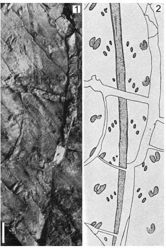
Identifying what species of animal made a trackway may be difficult of even impossible so trackways are sometimes given their own species names (called ichnospecies). Back in 1932, this particular trackway was assigned the ichnospecies Protichnites gallowayi based on the appearance of the tracks (shown below). The tracks were on a slab of rock which also showed molds of mudcracks indicating the animal was walking across a muddy exposed tidal flat. 


Eurypterid trackway from Braddy & Gass (2023). Scale bare 5 cm on top, 1 cm on bottom

With the modern reexamination of this trackway, Braddy & Gass (2023) renamed the ichnospecies to Palmichium gallowayi and believe the tracks appear to have been made by a eurypterid, quite possibly Brachyopterus stubblefieldi, a small (8 cm) eurypterid from the Middle Ordovician Period and known from fossils in Wales (a bit closer to us during the Ordovician). This makes this trackway one of the oldest examples of a eurypterid trackway in the world. A drawing of this eurypterid is shown below.


So, where was this trackway found? There's a park in Kingston called Hasbrouck Park. In older times, the hill, rising from the area along the Rondout Creek, was called the Vlightberg. Along the south side of this park are some steep cliffs which is where surface and underground cement mining was taking place over 100 years ago. It was Rosendale Natural Cement which I've written (and spoken) about numerous times. One small quarry area on the side of the cliffs was called Hill Quarry. The trackway was found on the south side of the entrance to the quarry in the Martinsburg Formation - a highly deformed shale and sandstone sequence from the Ordovician Period just below the famous Taconic unconformity with the overlying carbonate cement rocks.

Back in the Ordovician, a bit over 450 million years, ago, a eurypterid crawled up on a muddy tidal flat. What were they doing? Maybe molting. Maybe massing with other eurypterids to mate like the modern horseshoe crabs. Maybe just strolling in the moonlight - under a Moon that was closer to the Earth back then and forming more extensive tidal mud flats with more extreme tidal variations. The water lapping on the edge of the tidal flat would be warm - at the time we were in the Southern Hemisphere but much closer to the equator than we are today. After the eurypterid went about his business, the trackway baked in the sun the next day and the mud cracked. Then, in the next high tide, sand washed over the trackway and mudcracks and preserved them.

That sediment eventually became buried and lithified into sandstone. Then a mountain building event which formed the massive Taconic Mountains folded those sandstones deep underground. They eventually reached the surface again after tens of millions of years of erosion and were covered by a shallow sea which deposited a thick sequence of sediments (the cement rocks and overlying limestones).

We are very fortunate that humble little trackway made one evening hundreds of millions of years ago made it's way down to the present day for us to wonder about!

Sunday, November 26, 2023

Go and See

In the historical development of geology, there were conflicting ideas about the formation of crystalline rocks (the rocks we today refer to as igneous or metamorphic). In the late 1700s, an influential German mineralogist named Abraham Gottlob Werner: (1749-1817) argued that crystalline sediments chemically precipitated from an initial universal ocean early in Earth’s history. While he published little, and frail health precluded traveling beyond his local area, Werner was a very influential professor at the Freiberg Mining Academy where he infected students with an almost disciple-like fervor. This concept of rocks precipitating from ocean water became known as Neptunism.

Another famous early geologist was James Hutton (1726 –1797), a wealthy Scottish polymath who dabbled in medicine, chemical manufacturing, agriculture, and geology. Often called the “Father of Modern Geology”, he wrote Theory of the Earth in 1788 where he argued for the principle of uniformitarianism – the idea that the same processes that operate on Earth today were the same that have operated throughout Earth history. He also advocated that crystalline rocks formed gradually over time from the cooling and crystallization of molten rock or magma. This idea was in direct opposition to Werner’s idea of Neptunism and came to be known as Plutonism setting the stage for a vociferous debate between these two ideas in geology in the late 1700s.

Meanwhile, in France, a geologist named Nicolas Desmarest (1725-1815) was studying and mapping rocks in Auvergne, a mountainous area in central France. While his passion was geology, Desmarest supported himself with a government job as Inspector General and Director of Manufactures which enabled him to travel around the country, often on foot so he could examine the local rocks.

In Auvergne, Desmarest found columnar basalt lava flows which he was able to trace back to volcanic-like craters in the region. It was clear that the basalt lava was erupted from these extinct craters. He presented a geologic map of the area to the Paris Academy of Sciences which was later published in 1777. His results clearly supported the ideas of Plutonism.


Map of the Auvergne lava flows by Desmarest

Columnar basalt lava flows in the the Auvergne region

Extinct volcanoes in the Auvergne region

When Desmarest was approached by those who wished to debate Neptunism vs. Plutonism, he was reputed to have said “Go and see.” This quote, which appears in most introductory textbooks in historical geology, strongly resonates with modern geologists. Theorizing about the Earth is all well and good, but if your ideas don’t stand up to field checking, there’s little point debating it.

That’s why we have field trips in geology. It’s one thing to tell students that the Hudson Valley was once covered with a warm, shallow sea – a fact that they’ll dutifully write in their notebooks without questioning. It’s another to take them to a limestone rock outcrop on the side of a local highway and show them the abundant marine invertebrate fossils in the rock. Want to learn about the geology of the Hudson Valley? Go and see – look at the rocks and let them speak to you.