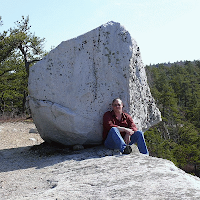
Earth has experienced a number of ice ages throughout its history - times when continents, especially at high latitudes, were covered with massive ice sheets. The last major ice age peaked around 18,000 years ago when the Hudson Valley was covered with thousands of feet of ice.
As glaciers advance along the landscape, they pick up and entrain particles ranging in size from clay to large boulders and everything in between. As glaciers melt, these sediments are then deposited. This unsorted debris deposited by glaciers is generally called till but a number of different features can form from till by different glacial processes.
A boulder train is one type of glacial deposit. It's basically a linear or fan-shaped deposit of glacial boulders (called glacial erratics) aligned with the past direction of ice flow. One local boulder train (NYSGA 1979 Field Guide) is just past where the Wallkill River flows into the the Rondout Creek between Rosendale and Kingston in Ulster County. In can be seen off Creek Locks Road about 2.7 miles from Rosendale (seen on Google Maps at 41° 51' 56" N, 074° 02' 32" W).
Note the gray rocks scattered across the creek here
The river has carried away all of the smaller material here leaving the larger boulders behind.
Boulders in the Rondout Creek
Not the best picture above, but there were no trespassing signs on the lawn area. One of these days I'll get a drone so I can get nice aerial shots of these types of features.
I think (but not positive) that another such boulder train is located in the middle of the Wallkill River half-way between the villages of New Paltz and Gardiner in Ulster County. It can be seen from Libertyville Road just south of the Ulster County Fairgrounds (or on Google Maps at 41° 43' 13" N, 074° 07' 52" W).
Possible boulder train in the Wallkill River (note the streamlined island)
Pictures of boulders in the Wallkill River
Not the best pictures again, but it was too difficult to get down the riverbank at the time and the other side of the river was private property (again, a drone would have been nice).
The exact processes that lead to the deposition of boulder trains is still poorly understood. Some researchers have traced boulder trains to a nearby cliff and have hypothesized that thin glacial ice and the front edge of the glacier have plucked boulders from the cliff and smeared them out as a boulder train,
It turns out that looking at the topography just north of this boulder train does show a small stream valley and possible source area in the woods. I did not hike in to investigate - maybe sometime this winter if it's not posted.
The point of all this. Just that when geologists claim our area was once covered with glaciers, it's because the landscape all around us preserves evidence of that glaciation if you just know where and how to look for it.


No comments:
Post a Comment