


 Unique Visitors
Here are before and after pictures of the Rondout Creek from Sunday afternoon, August 28, just after the rain stopped from Irene, and Sunday, September 4, one week later. The pictures were taken from the Route 32 bridge over the Rondout looking westward toward the Village of Rosendale (click to enlarge).
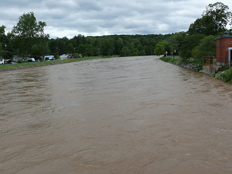

Note how close the water was to the berm protecting the homes and businesses along Main Street. That evening, a voluntary evacuation recommendation was issued for Main Street because of fears the creek would overtop the berm (fortunately, it didn't). Note also the incredible difference between "normal" creek water levels and the level after Irene.
On the banks of the Rondout, next to the bridge and across the creek from St. Peter's Church, is a small wooden shed. This shed is a United States Geological Survey stream gaging station. USGS Streamflow data has been collected here sporadically between 1902 and 1927 and pretty much constantly since 1927.
In that century of data collection, the amount of water in the creek from Irene was the highest recorded at 36,500 cubic feet per second (cfs) of discharge! It was also the highest water level (26.94 feet) ever recorded there.
Here's the raw data since 1927. The columns are the water year (USGS defines this from October 1 through September 30), date of measurement, gage height in feet, and discharge in cubic feet per second (cfs).
The second (35,800 cfs / 26.80 ft) and third (30,900 cfs / 23.93 ft) highest flooding events occurred on October 16 and August 19 respectively in 1955. They're an interesting story. On August 12, the remnants of hurricane Connie dumped up to 15 inches of rain in parts of the Hudson Valley and this event was quickly followed by hurricane Diane which struck less than a week later on August 17 dumping another 7+ inches of rain into the
To add insult to injury, a slow moving coastal storm struck the area two months later on October 16. This storm dumped up to 18 inches of rain in parts of the Hudson Valley. Both times, the Village of Rosendale flooded as the Rondout overtopped its banks.
It's not a surprise to geologists that the Village of Rosendale is susceptible to flooding from the Rondout because even a quick glance at the topography shows that the village is situated on a natural floodplain (the south side of the creek is significantly higher than the north side).


After this flooding, the U.S. Army Corp of Engineers came in, blasted some rock slightly downstream at Lefever Falls, dredged the creek, and built up the berm now protecting Main Street of Rosendale. If that had not been done, Main Street would have flooded this year and quite possibly on April 3, 2005 as well (anyone else remember those rains and flooding?).
There are some interesting things you can do with this stream data. You can, for example, rank it by discharge where 1 is the year with the highest discharge (2011) and 85 is the year with the lowest (1967) since there are 85 data points between 1927 and 2011 inclusive. Now we can use the following formula to calculate the recurrence interval in years for each discharge:
Recurrence Interval = (n + 1) / m
where n is the number of data points (85) and m is the rank of each data point. Then we can graph the recurrence interval in years (on a logarithmic scale) against the discharge in cubic feet per second (cfs), sketch a trendline through the points, and obtain the following:
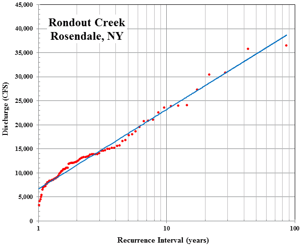
According to the USGS, flood stage occurs around 15,000 cfs (a gage height of 18 ft or so) and we can see from this graph that such a condition occurs about once every 3 years (find 15,000 cfs, move over to blue trendline, and then down to the x-axis). The most recent flood has, of course, a recurrence interval of 85 years since it's the highest in 85 years of record (basically a 100-year flood event). This is a simplistic analysis, of course, because it's hard to talk about 100-year flood events with barely a century of data. I'd want at least 1,000 years of data to define 100-year flood events but we have to work with what we have.
Below is an interesting graph showing how the quickly the river rose. On Sunday, August 28, between midnight and noon (which is the time it was raining the heaviest), the river rose from about 10 feet to 27 feet. The red line is flood stage (hit around 6 am) meaning folks went to bed with a normal river and woke up to raging floodwaters.

Below is the discharge (amount of water in the Rondout flowing by each second) measured in cubic feet per second (cfs). The vertical scale is logarithmic. Discharge increased from around 500 cfs to 36,500 cfs in that same time period (a 73 fold increase in the volume of water!).

It was essentially a flash flood event - even more so for those poor folks in narrow stream valleys up in the Catskills.
This is interesting to read as I wait for Sandy to hit! I am new to the area, living on Rte 213. I hope everyone stays safe!
ReplyDeleteWe're considering purchasing a home on Main Street and found this very interesting and informative as well. Thank you!
ReplyDelete