


 Unique Visitors
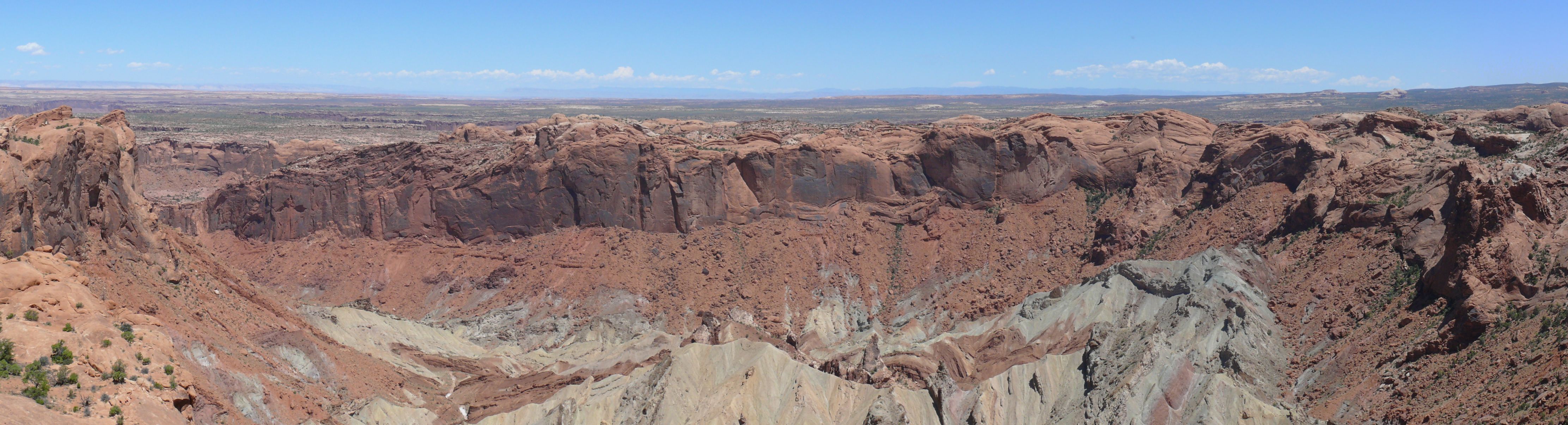

Upheaval Dome is an odd feature that stands out like a sore thumb when viewing the Canyonlands area from above. Here's what it looks like from satellite imagery in Google Earth (38° 26' 05" N, 109° 57' 05" W):

So, when a geologist sees a feature like this, they wonder how it formed. There are generally only three things that can cause circular features like this - a meteorite impact, volcanism, or an intrusion of magma or salt. So which was it?
Well, we can rule out volcanism. In this area of the Colorado Plateau, the only rocks are flat-lying sedimentary strata and there are no traces of any volcanic rocks in or around Upheaval Dome. Here's an example of the layer-cake geology of Canyonlands from a hiking trail near Grand View Point.

For years, the two competing hypotheses for the formation of Upheaval Dome were the intrusion of a salt diapir (a magma intrusion is ruled out for the same reason as volcanism) or a meteorite impact. Let's look at each in turn.
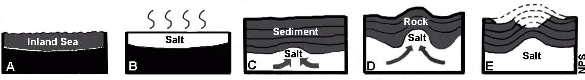
The diagram above illustrates how a salt intrusion could have formed this feature. Back in the Pennsylvanian Period of geologic time, some 310 million years ago, the area was flooded with seawater and formed what we today call the Paradox Basin (PaB in image at left below).

Ron Blakey, NAU Geology, http://www2.nau.edu/rcb7/garm.html
Northeast of the basin, the rising Uncompahgre Uplift was eroding and sediments washed down into the basin eventually filling in the sea and covering the salt with thick layers of clastic sedimentary rocks (clastic rocks are sedimentary rocks formed from sediments - e.g. sandstone).
The pressure from thousands of feet of overlying sediments causes the underlying salt to become plastic and flow. Being less dense than the ovelying material, it tends to form a plug (diapir) which pushed upward, warping and deforming the overlying flat-lying strata.
Lots of erosion then excavated deeply into this structure forming the feature we see today (click on image below to enlarge).

Harris, et al. 2004. Geology of National Parks. Kendall Hunt
The competing hypothesis is illustrated below:

In this scenario, the strata are flat-lying, the salt deposits beneath have not mobilized or substantially deformed the overlying material, and one day, sometime after the Jurassic Period a meteorite came crashing down. The meteorite formed a large impact crater, deformed the flat-lying sedimentary strata, and was then deeply eroded to its present-day shape.

So, how do you tell the difference between these two competing stories? It's a national park so you can't just drill down into the structure to see. The National Park Service website doesn't take a position, just presents both ideas. The textbook I use for my Geology of the National Parks course favors the salt intrusion hypothesis. I believe that the evidence, however, favors the impact hypothesis today.
In Geology of the Upheaval Dome Impact Structure, Southeast Utah, (Kriens, Shoemaker, & Herkenhoff, 1999, Journal of Geophysical Research - Planets, 104), the results of fieldwork in the area presented some good evidence that Upheaval Dome was, in fact, an impact structure even though most geologists at the time favored the salt intrusion hypothesis. Some of their evidence included:
1. A deposit of what they interpret to be impactites - partially melted rocks formed from meteorite impact.
2. Shatter cones (conical fracture features formed by meteorite impact) in the Moenkopi Formation.
3. Seismic refraction work indicated the salt horizon is at least 500 meters below the structure, too deep.
4. Folds, faults, and clastic dikes around the structure are consistent with an impact origin.
The kicker came in 2008 when Buchner and Kenkmann published in Geology their discovery of shocked quartz grains from the Kayenta Sandstone. Shocked quartz is quartz that has been subjected to a shock wave - generally from either a meteorite impact or nuclear detonation. The shock waves from these events deform the crystalline lattice of the quartz crystals and this can easily be seen when examining the mineral under a microscope using polarized light.
This feature, which can best be seen from space, formed from space. A bad day for the dinosaurs when a several hundred meter diameter meteorite came crashing down!

Upheaval Dome from the International Space Station, 2007
No comments:
Post a Comment