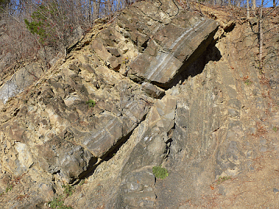
Shale is made primarily from quartz and various clay minerals (lithified mud). Sandstone is made from quartz (SiO2). Dolostone is basically limestone (calcium carbonate or CaCO3) with some magnesium tossed in -- (Ca,Mg)(CO3)2. They're very different types of rocks.
Geologists call the unit on the right (the older one, since it's below the other), the Austin Glen Formation and they call the unit on the left (the younger one), the Rondout Formation. It's actually very easy to distinguish them from each other in the field (they look more different in person than they do in the image).
This contact, where the Rondout Formation lies on top of the Austin Glen Formation and they both have different orientations is not just seen here. You can drive to other locations in the area to see this as well. Geologists call this type of contact an angular unconformity.
Fossil evidence in the Austin Glen indicates it's from a period of time called the Middle Ordovician Period (let's say 465 Ma). The Rondout Formation is from the Late Silurian Period (let's say 420 Ma). That means that there's some 45 million years missing in that unconformity! Missing rock strata indicates from that from around 465 Ma to 420 Ma, this area was undergoing a time of erosion - there were no sediments accumulating to later form rock layers.
A very basic principle in geology, first formulated in the mid-1600s by Nicolaus Steno in Italy, is that of original horizontality. What this means is that sediments originally accumulate in horizontal layers which then lithify into horizontally-bedded sedimentary rocks. If the layers are tilted, such as the one's above, then some force later tilted them. Another of Steno's principles is superposition - the basic idea that in layered sedimentary rocks, the oldest layers will be at the bottom. Pretty simple.
So what does the outcrop above tell us? An entire sequence of events...
1. Around 465 Ma, the Austin Glen Formation was laid down as marine muds and with periodic influxes of sands in horizontal beds in a deep basin (the fossils tell us this). They gradually accumulated and were buried. Over time they lithified into shales and sandstones.
2. Sometime between 465 and 420 Ma, the Austin Glen rocks were tilted by some type of event. Looking at numerous outcrops reveals that these layers were actually folded and cut through by faults due to horizontal shortening in a present-day east-west direction.
3. Around 420 Ma, the Roundout Formation was deposited as horizontal sediments in a shallow, tidal-flat environment in a hot, arid climate. Eventually these sediments were buried and lithified into beds of dolostone. At this time, the angular unconformity existed between the Rondout and Austin Glen Formations but it too would have been horizontal.
4. At some time younger than 420 Ma, Everything was folded and faulted yet again by another shortening event (again in a present-day east-west direction).
In other words, what this outcrop represents is two distinct tectonic events. We know, from studying metamorphic and igneous rocks to the east, that these were huge mountain-building events. To form each of the rock layers, tilt them twice, erode them flat, etc. will take very long spans of time - in this case tens of millions of years. Some time later, I may discuss these but the post is getting long enough as it is.
One last thing I'll mention is that in 1788, a Scottish physician and amateur geologist named James Hutton saw an outcrop at Siccar Point on the coast of southwestern Scotland. At Siccar Point, tilted strata of red sandstone dated around 345 Ma overlie almost vertical strata of graywacke (a type of sandstone) dated around 425 Ma (80 million years of missing time). It's almost exactly analagous to the Taconic unconformity in Catskill.
Siccar Point from Wikipedia
Back in Hutton's day, they didn't know the ages of these rocks, but Hutton did recognize that such an outcrop showed an immense span of time. To create such an outcrop through naturalistic processes would have taken far, far longer than the traditional 6,000 year Biblical age of the Earth. It was the beginning of modern geology.
I could keep going for pages but I guess I'll stop here and pick this up another time.


I have some ideas of my own concerning unconformities. Some astronomers estimate that the mass of the comets of the Hills Cloud may equal the mass of 100 Jupiters. Since comets are almost entirely ices, they could contain billions of times the amount water on earth. Also, since comets are low-density snow they have an insulation factor of about R-one zillion, so even a small amount of radioactive decay would melt the ice in the core. With so much liquid water, probabilities favor bacterial life beginning in comets, with or without panspermia. Chemotrophic bacteria, then, would thrive on chemically-reduced nebular dust & chondrules in the water. When waste minerals in solution reach the saturation point at the ice/water boundary, the minerals crystallize out of solution & precipitate to the center. In large comets where the T&P exceeds the critical point of water, the saturation quartz goes negative with increasing T & P, so quartz would crystallize at the hottest T&P on the surface of the growing rocky core, cementing the other mineral grains together like puzzle pieces to form granite.
ReplyDeleteIf so, then why isn't earth pock marked with comet impact craters? Actually, it is, but with a twist. Low density comet impacts on planets with atmospheres don't form deep round craters with melt rock and raised rims like rocky asteroid impacts, such as Meteor Crater in Arizona, but rather form shallow elongated basins, largely without melt rock and without raised rims, like Hebes Chasma on Mars.
http://www.esa.int/esaSC/SEM565R03EF_index_1.html#subhead3
The raised plateau in the center of Hebes is the hydrothermal rock of the comet core, extruded in the direction of the long axis. Besides granite, comet rock is as varied and prolific as terrestrial (ter.) stone. For ex., schist is formed at cooler T in a manor similar to terrestrial stromatolites, where a biofilm grows directly on the rocky core, forming stalagmite-like stromatolites that give the resulting rock the appearance of small-scale foliation. Even clastic rock like quartzite and conglomerate can be formed in the comet cores in gravitationally-bound comet clusters of the Outer Oort Belt where comet impacts are frequent, & tidal forces from nearby orbiting comets cause multiple cores to grind together, reducing granite to sand & clay. After lithifying the sand to quartzite and clay to shale, subsequent impacts grind the quartzite into smooth clastic cobbles and quartz pebbles that may lithify to conglomerate. One should suspect any tilted strata (angular unconformity) to be of comet origin, especially if it contains quartzite. The following rocks are always of comet origin: granite, schist, gneiss, serpentinite, graywacke, hornfel, greenstone or TTG, etc., but I don't want to leave the impression that most surface stone is extraterrestrial. For ex., the horizontal strata of the Grand Canyon above The Great Unconformity are entirely ter., and these formations demonstrate the relative rates of weathering between ter. "stone" and comet "rock." Think how many mountaintops are capped with comet quartzite, & compare this impervious rock with the rapid rate that the Colorado River sliced through the ter. stone of the Grand Canyon.
Additonally, the center of a comet core is composed of metal ores, since ionic bonds release more energy than covalent bonds, so bacteria attack metals first. The great mining basins are comet impact basins, such as Witwatersrand and Athabasca, as well as Banded Iron Formations. In addition to rock, comets also transport vast quantities of loose sand, gravel and clay, along with crustal veneer of CB chondrules that hardens over time by exposure to galactic cosmic rays. These CB chondrules froming the comet crust have a high metallic iron content, but since the iron is contaminated with many elements, it's useless for industry. Meteorite labs are familiar with comet crust “meteorwrongs” which they routinely dismiss as probable industrial slag.
dave19128@gmail.com