


The two-year community college where I teach (which I do NOT speak for in any way, shape or form) is part of the State University of New York (SUNY) system.
There has been a lot of talk (and policy) lately from SUNY and the Governor's Office about time to completion and retention. Students often take more than two years to complete the two-year degrees and many never graduate. SUNY and various politicians (both local and national) want to improve those numbers.
Of course, most of the time, people who talk about such things are surprisingly clueless about facts on the ground. Let's start with time to completion first.
A typical two-year degree is 60 credits or so. That's 15 credits each semester for those of you poor in math. That assumes no need for developmental classes. Unfortunately, a significant number of our local high school graduates come into college requiring developmental writing before getting into Freshman English 101 or developmental math (sometimes several of these) before getting into a College Algebra course (the bare minimum math needed). Depending on what they want to major in, they may need a number of math courses (Want to go into science? You need several courses beyond even Calculus I).
Also, virtually all of my students work - some work full-time. They have to because college is expensive (yes, community colleges are cheaper, but for some of us, even cheaper is too expensive). Many of my students don't do well because they don't have time to do well. Between working, family obligations, life stresses, etc. they simply can't do a minimum of 15 credits each semester successfully. So they take longer. If they eventually graduate, I consider that a success, even if it takes them 4 years. SUNY considers them failures.
Want to fix that SUNY? Make college cheaper so students don't have to work outside jobs for more hours than they attend classes.
Retention - keeping a student until they graduate - is also problematic given two factors SUNY also appears to be clueless (intentionally or not) about. First, we're open admission. We take anybody who can write a check (or fill out the financial aid forms). I've had severely autistic kids in my class. I've had people who I'm convinced have IQs well below the norm in my class. These kinds of cognitive deficiencies can't be addressed by better teaching or increased tutoring. They're real barriers. It's tough watching these kids crash and burn because they come to class and often try hard but I'm not making up special grades for them because they're good kids. They're going to fail and I'm not the one who set them up for that.
At the community college level, we don't give everyone a degree, we give everyone an equal opportunity to earn a degree. SUNY considers us a failure because we can't graduate all of these kids. We could improve our statistics by becoming selective. But that just defeats this mission of us as a community college with equal access.
Another problem, which I've written about before, is that many of our students transfer before earning a degree with us. If a student starts at our school, and transfers to a four-year university after their first year, and later earns a bachelor's degree, they are counted as a failure at our institution since they attended but didn't earn a degree with us. It's absolutely ridiculous and needs to be changed.
So, Governor Cuomo, NYS Legislature, Chancellor Zimpher, and the SUNY Board. Want to improve education at the SUNY community colleges? STOP CUTTING OUR FUCKING FINANCIAL SUPPORT AND SUPPORT FOR STUDENTS! Make college (especially community college) CHEAP and students will be better able to succeed and graduate on time. Get us money for the auxiliary support these students need with English and mathematics. Get us funds to hire more full-time faculty instead of having MOST courses taught by part-time faculty who are not invested in the institution and are afraid to uphold academic standards (a whole other issue). Change your statistics to reasonable measures (transfer out of a community college to a four-year institution is a SUCCESS, not a failure). Get your heads out of your asses and visit community colleges and talk to faculty and staff (not presidents and Board members).
Enough ranting for today.
Monday, October 12, 2015
Wednesday, September 23, 2015
Super Blood Moon Eclipse, Oh My!
Where to start...
I wrote about all of this before and am recycling a lot of the material from previous posts.
SuperMoon (March 12, 2011)
"Supermoon" Nonsense (May 6, 2012)
Blood Moon Bullshit (April 13, 2014)
Johannes Kepler (1571-1630) is remembered by astronomers for developing the Three Laws of Planetary Motion which showed that planets orbited the Sun in elliptical orbits, not the previously believed perfect circles. Similarly, our Moon orbits the Earth in an ellipse. This means that it is sometimes a bit closer to the Earth (perigee) and sometimes a bit further (apogee).

This coming Sunday, September 27, 2015, the Moon will be full (as it is every 29.53 days). It will also be 356,876 kilometers from Earth - the closest perigee approach for the entire year. Sometimes perigee corresponds to the full moon phase, sometimes not. It is however, completely predictable and understood (here's an online apogee and perigee calculator).
Is there anything special about this distance on September 27? Not really. If you want really extreme perigees, you missed the last one if you're younger than 85 years old. It occurred on January 15, 1930 when the Moon was 356,397 km from the Earth. Forget about the next extreme perigee, it will occur on January 1, 2257 when the Moon is a mere 356,371 km away.
When perigee occurs near the time of a full moon, the news media has taken to calling these events "Supermoons". "Supermoon" is a mostly bullshit term which was popularized by an astrologer (not astronomer, there is a difference!) named Richard Nolle. I say mostly bullshit because it is grounded in real astronomy (the orbit and phases of the Moon) but attributes special astrological (imaginary) qualities to a Moon that's at perigee when it's full (there's the bullshit part). All kinds of bad things are supposed to happen. They don't.
Technically, these events are called a perigee-syzygy where syzygy refers to an astronomical alignment of 3 or more celestial objects - in this case the Sun, Earth, and Moon. Perigee and apogee are not linked to the Moon's phases because of differences in their cycles. The amount of time from perigee to perigee is 27.55455 days. The amount of time from full Moon to full Moon is 29.53059 days. That's a two-day difference.
Since:
14 x 29.53059 days = 413.43 days
and
15 x 27.55455 days = 413.32 days
These cycles approximately coincide every 413 days. So, since we have a perigee full moon on September 27, 2015, we can expect a perigee full moon again 1 year and 48 days later on November 14, 2016. Guess what the Lunar Perigee and Apogee Calculator says? That's right, another perigee full moon on November 14, 2016. (science works!). That perigee will be even closer at 356,511 km!
How significant are these perigee full moons? Does the Moon really look much larger in the sky at these times? That too can be calculated (yea for math!). For the interested, the formula is:
 δ = 2 tan-1 [(D/2)/d]
where D is the diameter of the Moon, d is the distance from the Earth to the Moon, and δ is the angular size of the Moon in the sky.
The mean diameter of the Moon is 3,476 km. Let's calculate the difference in this month's "super" Moon angular diameter versus that of the "average" Moon (384,403 km distant).
"Super" Moon:
δ = 2 tan-1 [(D/2)/d] = 2 tan-1 [(3,476 km/2)/356,953 km] =0.558°
"Average" Moon:
δ = 2 tan-1 [(D/2)/d] = 2 tan-1 [(3,476 km/2)/384,403 km] = 0.518°
That's a difference of 7.7% when looking at the Moon in the night sky. Here is the difference between an apogee and perigee full moon (actual images from 2006):

Noticeable in the picture, but could you tell from one month to the next? And this is NOT how large the full Moon appears in the sky. Go outside anytime the Moon is full, outstretch your arm and extend your pinkie finger. The fingernail on your pinkie finger will easily cover the Moon.

Turns out there's also a total lunar eclipse Sunday evening that will be visible across the United States. Also, and this is depressingly predictable for the Hudson Valley during interesting astronomical events, the weather forecast currently says "partly cloudy" for Sunday night (seriously, it's always cloudy around here when anything of astronomical significance occurs).
This NASA site has useful information if it happens to be clear where you on Sunday evening (yes, NASA calls it a "supermoon" - don't get me started on their public outreach pandering).

This is where the Moon will be around 10:30 pm Sunday night in the
Mid-Hudson Valley.

One of the neat things about an eclipsed Moon is that it turns a beautiful reddish color.
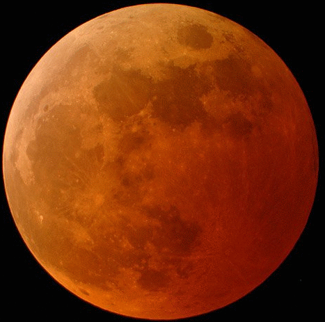
Why is that? Well let's first look at what causes lunar eclipses. As shown in the diagram below (not in any way to scale), we see that an eclipse occurs when the Moon moves into the Earth's shadow - the umbra (there are penumbral eclipses, but they're too dim for most people to notice). When the Moon is in this position, on the opposite side of the Earth from the Sun, it's at its full moon phase (the side of the Moon facing us is normally fully lit by the Sun).

So, why don't we have total lunar eclipses every month when the Moon is in that position? To answer that, let's first look at the true scale of the Earth and the Moon (size and distance).

Now consider that the Moon does not orbit the Earth is the same plane as the ecliptic (the plane in which the Earth orbits the Sun). The Moon's orbit is tilted by just over 5° from the ecliptic. About half the time the Moon is below the ecliptic (and can't pass into the Earth's umbral shadow) and about half the time the Moon is above the ecliptic (and also can't pass into the Earth's umbral shadow). Only when the Moon is passing through the ecliptic (points called the ascending or descending nodes) at the same time it happens to be a full moon, can we have a total lunar eclipse (you can also have partial and penumbral eclipses if things are quite exactly lined up).

For the 100 years from 2000 through 2099, there will be 85 total lunar eclipses (and 87 penumbral and 58 partial).
OK, back to the red Moon during an eclipse. If the Earth had no atmosphere, the eclipsed Moon would be dark. But because the Earth has an atmosphere and the gases in our atmosphere (78% nitrogen and 21% oxygen) scatter the shorter wavelength light at the blue end of the color spectrum, the longer wavelength reddish light makes it through. This is why the sky looks blue on a sunny day (the blue light being scattered about) and why sunsets and sunrises look red (the longer wavelengths making it through the thick atmosphere on the horizon to our eyes). As the reddish light passes through our atmosphere, it's also refracted (bent) and this allows it to faintly illuminate the Moon during a total eclipse.

This is called science, boys and girls. Basic knowledge of eclipses goes back thousands of years to the ancient Babylonians and since then we've learned quite a bit about how it all works. Using celestial mechanics, we can predict, with virtual 100% certainty, that there will be a total lunar eclipse on September 14, 2099 at 16:57:52 UTC visible in North America (mark your calendars).
OK, now here's where I'm going to piss some people off. Crazy Texas televangelist John Hagee from Cornerstone Church in San Antonio is preaching that this month's eclipse is the fourth of a series of four "blood moon" eclipses heralding the end of the world (the ever-popular apocalypse).
So, what is a blood moon? According to CBN News (Pat Robertson's organization):
"A blood moon is when the Earth comes between the sun and the moon," Hagee explained. "And the sun is shining through the atmosphere of the Earth and casts up on the moon a red shadow. And so the moon appears to be red."
Um, OK, but that's what happens with virtually all total lunar eclipses. Now all of a sudden the dumb ass lazy journalists writing for all these media outlets are calling the eclipse a "blood moon" (just Google the phrase to see)! What the fuck? There's nothing special at all about this particular eclipse.
But wait, Steve, you might say, Hagee is arguing that this is a special sequence of four eclipses. Again, according to CBN News:
Well, if God's controlling the Sun and Moon, he's doing it in such a way that it's completely indistinguishable from perfectly natural physical processes (e.g. gravity). Go to the NASA Eclipse page to view a 5,000 year calendar of lunar eclipses to see how perfectly predictable it all is.
Yes, there are total lunar eclipses on Passover and Sukkot in 2014 and 2015 (October 8, 2014, not September as the news article incorrectly states, but oh well). Is there something special about this? Well, think about the following. Total lunar eclipses can only occur on the full moon. The Jewish holidays of Passover and Sukkot are tied to the Jewish lunar calendar. Passover starts on the night of the full moon after the vernal equinox and Sukkot also starts on a full moon six lunar months later.
Since these Jewish holidays start on the full moon, and lunar eclipses are on a full moon, it's certainly inevitable that they should line up sometimes. Lunar eclipses also occur in cycles and tetrads (a group of 4 eclipses such as this) are not all that unusual.
As the following table from Universe Today shows, there are 8 of these tetrad eclipses in the 21st century:
No big deal. If anyone's convinced that the end of the world is nigh because of these lunar eclipses, I'd be happy to take any extra money off your hand - won't need it after you're raptured anyway, right? The world will end because of human stupidity and greed, not because of a capricious god.
So that's why your humble science professor does not like the terms "supermoon" and "blood moon" even though they're all over news stories of the coming eclipse. These words are grounded in pseudoscientific astrological and religious nonsense and give the impression that these completely natural and predictable astronomical events have special significance for humans. They don't. Go out and bask in the beauty of this celestial show. I will. Just remember that this event was predicted by scientists, not astrologers or televangelists.
I wrote about all of this before and am recycling a lot of the material from previous posts.
SuperMoon (March 12, 2011)
"Supermoon" Nonsense (May 6, 2012)
Blood Moon Bullshit (April 13, 2014)
Johannes Kepler (1571-1630) is remembered by astronomers for developing the Three Laws of Planetary Motion which showed that planets orbited the Sun in elliptical orbits, not the previously believed perfect circles. Similarly, our Moon orbits the Earth in an ellipse. This means that it is sometimes a bit closer to the Earth (perigee) and sometimes a bit further (apogee).

The ellipticity of this orbit is exaggerated
This coming Sunday, September 27, 2015, the Moon will be full (as it is every 29.53 days). It will also be 356,876 kilometers from Earth - the closest perigee approach for the entire year. Sometimes perigee corresponds to the full moon phase, sometimes not. It is however, completely predictable and understood (here's an online apogee and perigee calculator).
Is there anything special about this distance on September 27? Not really. If you want really extreme perigees, you missed the last one if you're younger than 85 years old. It occurred on January 15, 1930 when the Moon was 356,397 km from the Earth. Forget about the next extreme perigee, it will occur on January 1, 2257 when the Moon is a mere 356,371 km away.
When perigee occurs near the time of a full moon, the news media has taken to calling these events "Supermoons". "Supermoon" is a mostly bullshit term which was popularized by an astrologer (not astronomer, there is a difference!) named Richard Nolle. I say mostly bullshit because it is grounded in real astronomy (the orbit and phases of the Moon) but attributes special astrological (imaginary) qualities to a Moon that's at perigee when it's full (there's the bullshit part). All kinds of bad things are supposed to happen. They don't.
Technically, these events are called a perigee-syzygy where syzygy refers to an astronomical alignment of 3 or more celestial objects - in this case the Sun, Earth, and Moon. Perigee and apogee are not linked to the Moon's phases because of differences in their cycles. The amount of time from perigee to perigee is 27.55455 days. The amount of time from full Moon to full Moon is 29.53059 days. That's a two-day difference.
Since:
14 x 29.53059 days = 413.43 days
and
15 x 27.55455 days = 413.32 days
These cycles approximately coincide every 413 days. So, since we have a perigee full moon on September 27, 2015, we can expect a perigee full moon again 1 year and 48 days later on November 14, 2016. Guess what the Lunar Perigee and Apogee Calculator says? That's right, another perigee full moon on November 14, 2016. (science works!). That perigee will be even closer at 356,511 km!

where D is the diameter of the Moon, d is the distance from the Earth to the Moon, and δ is the angular size of the Moon in the sky.
The mean diameter of the Moon is 3,476 km. Let's calculate the difference in this month's "super" Moon angular diameter versus that of the "average" Moon (384,403 km distant).
"Super" Moon:
δ = 2 tan-1 [(D/2)/d] = 2 tan-1 [(3,476 km/2)/356,953 km] =0.558°
"Average" Moon:
δ = 2 tan-1 [(D/2)/d] = 2 tan-1 [(3,476 km/2)/384,403 km] = 0.518°
That's a difference of 7.7% when looking at the Moon in the night sky. Here is the difference between an apogee and perigee full moon (actual images from 2006):

Noticeable in the picture, but could you tell from one month to the next? And this is NOT how large the full Moon appears in the sky. Go outside anytime the Moon is full, outstretch your arm and extend your pinkie finger. The fingernail on your pinkie finger will easily cover the Moon.

Not as big as it looks here!
Turns out there's also a total lunar eclipse Sunday evening that will be visible across the United States. Also, and this is depressingly predictable for the Hudson Valley during interesting astronomical events, the weather forecast currently says "partly cloudy" for Sunday night (seriously, it's always cloudy around here when anything of astronomical significance occurs).
This NASA site has useful information if it happens to be clear where you on Sunday evening (yes, NASA calls it a "supermoon" - don't get me started on their public outreach pandering).


One of the neat things about an eclipsed Moon is that it turns a beautiful reddish color.
Why is that? Well let's first look at what causes lunar eclipses. As shown in the diagram below (not in any way to scale), we see that an eclipse occurs when the Moon moves into the Earth's shadow - the umbra (there are penumbral eclipses, but they're too dim for most people to notice). When the Moon is in this position, on the opposite side of the Earth from the Sun, it's at its full moon phase (the side of the Moon facing us is normally fully lit by the Sun).
So, why don't we have total lunar eclipses every month when the Moon is in that position? To answer that, let's first look at the true scale of the Earth and the Moon (size and distance).
Now consider that the Moon does not orbit the Earth is the same plane as the ecliptic (the plane in which the Earth orbits the Sun). The Moon's orbit is tilted by just over 5° from the ecliptic. About half the time the Moon is below the ecliptic (and can't pass into the Earth's umbral shadow) and about half the time the Moon is above the ecliptic (and also can't pass into the Earth's umbral shadow). Only when the Moon is passing through the ecliptic (points called the ascending or descending nodes) at the same time it happens to be a full moon, can we have a total lunar eclipse (you can also have partial and penumbral eclipses if things are quite exactly lined up).
For the 100 years from 2000 through 2099, there will be 85 total lunar eclipses (and 87 penumbral and 58 partial).
OK, back to the red Moon during an eclipse. If the Earth had no atmosphere, the eclipsed Moon would be dark. But because the Earth has an atmosphere and the gases in our atmosphere (78% nitrogen and 21% oxygen) scatter the shorter wavelength light at the blue end of the color spectrum, the longer wavelength reddish light makes it through. This is why the sky looks blue on a sunny day (the blue light being scattered about) and why sunsets and sunrises look red (the longer wavelengths making it through the thick atmosphere on the horizon to our eyes). As the reddish light passes through our atmosphere, it's also refracted (bent) and this allows it to faintly illuminate the Moon during a total eclipse.
This is called science, boys and girls. Basic knowledge of eclipses goes back thousands of years to the ancient Babylonians and since then we've learned quite a bit about how it all works. Using celestial mechanics, we can predict, with virtual 100% certainty, that there will be a total lunar eclipse on September 14, 2099 at 16:57:52 UTC visible in North America (mark your calendars).
OK, now here's where I'm going to piss some people off. Crazy Texas televangelist John Hagee from Cornerstone Church in San Antonio is preaching that this month's eclipse is the fourth of a series of four "blood moon" eclipses heralding the end of the world (the ever-popular apocalypse).
So, what is a blood moon? According to CBN News (Pat Robertson's organization):
"A blood moon is when the Earth comes between the sun and the moon," Hagee explained. "And the sun is shining through the atmosphere of the Earth and casts up on the moon a red shadow. And so the moon appears to be red."
Um, OK, but that's what happens with virtually all total lunar eclipses. Now all of a sudden the dumb ass lazy journalists writing for all these media outlets are calling the eclipse a "blood moon" (just Google the phrase to see)! What the fuck? There's nothing special at all about this particular eclipse.
But wait, Steve, you might say, Hagee is arguing that this is a special sequence of four eclipses. Again, according to CBN News:
"Blood moons are set to appear in April 2014, on
Passover, and then again in September 2014 during the Feast of
Tabernacles, or Sukkot.
The timing is the same for 2015 -- a total of four blood moons, all appearing on Jewish feast days.
"The sun and the moon and the Earth are controlled
by God almighty," Hagee said. "He is the one that is getting them in a
direct alignment on a certain day at a certain time -- but each time,
it's a Passover or Sukkot."
Well, if God's controlling the Sun and Moon, he's doing it in such a way that it's completely indistinguishable from perfectly natural physical processes (e.g. gravity). Go to the NASA Eclipse page to view a 5,000 year calendar of lunar eclipses to see how perfectly predictable it all is.
Yes, there are total lunar eclipses on Passover and Sukkot in 2014 and 2015 (October 8, 2014, not September as the news article incorrectly states, but oh well). Is there something special about this? Well, think about the following. Total lunar eclipses can only occur on the full moon. The Jewish holidays of Passover and Sukkot are tied to the Jewish lunar calendar. Passover starts on the night of the full moon after the vernal equinox and Sukkot also starts on a full moon six lunar months later.
Since these Jewish holidays start on the full moon, and lunar eclipses are on a full moon, it's certainly inevitable that they should line up sometimes. Lunar eclipses also occur in cycles and tetrads (a group of 4 eclipses such as this) are not all that unusual.
As the following table from Universe Today shows, there are 8 of these tetrad eclipses in the 21st century:
| Eclipse #1 | Eclipse #2 | Eclipse #3 | Eclipse #4 |
| May 16th, 2003 | November 9th, 2003 | May 4th , 2004 | October 28th, 2004 |
| April 15th, 2014*+ | October 8th, 2014 | April 4th, 2015*+ | September 28th, 2015 |
| April 25th, 2032 | October 18th, 2032 | April 14th, 2033*+ | October 8th, 2033 |
| March 25th, 2043* | September 19th, 2043 | March 13th, 2044 | September 7th, 2044 |
| May 6th, 2050 | October 30th, 2050 | April 26th, 2051 | October 19th, 2051 |
| April 4th, 2061*+ | September 29th, 2061 | March 25th, 2062* | September 18th, 2062 |
| March 4th, 2072 | August 28th, 2072 | February 22nd, 2073 | August 17th, 2073 |
| March 15th, 2090 | September 8th, 2090 | March 5th, 2091 | August 29th, 2091 |
| *Paschal Full Moon | |||
| +Eclipse coincides with Passover | |||
No big deal. If anyone's convinced that the end of the world is nigh because of these lunar eclipses, I'd be happy to take any extra money off your hand - won't need it after you're raptured anyway, right? The world will end because of human stupidity and greed, not because of a capricious god.
So that's why your humble science professor does not like the terms "supermoon" and "blood moon" even though they're all over news stories of the coming eclipse. These words are grounded in pseudoscientific astrological and religious nonsense and give the impression that these completely natural and predictable astronomical events have special significance for humans. They don't. Go out and bask in the beauty of this celestial show. I will. Just remember that this event was predicted by scientists, not astrologers or televangelists.
Sunday, June 21, 2015
Stone Church in Dover Plains
My wife and kids don't often hike with me but today was Father's Day so we went off to a place called Stone Church in Dover Plains - an easy walk to a very cool place.
So what is Stone Church? It's a natural rock formation near Dover Plains in eastern Dutchess County where a stream has cut out and eroded a neat opening in a cliff which evokes the arched window of a Gothic cathedral.
The trailhead is easy to miss. There's a historical marker off Route 22 in the middle of Dover Plains showing the location (there's no direct parking, check out this brochure for parking locations).

Interested in Sassacus and the Pequot War? Read more about it here.
Walk up what looks like a driveway...

And you'll be at the start of the trail...

Beautiful granite steps lead down to a mowed path, lined with young maple trees, through a meadow...


The path then winds through some woods (with mature maples lining the trail)...

And I learned something I didn't know. Hudson River School artist Asher Durand once sketched Stone Church (c. 1847)...

The trail continues along the creek...

Around a corner is the opening - the Stone Church...

This is why it's not a good idea to go for a hike on a Sunday afternoon. There were many people here (too many for me to properly enjoy it - I'll have to return on a week day sometime soon). My wife at the entrance (other people are strangers)...

The view inside...

Really cool place. I will definitely have to go back and explore more when there are less people around and when I'm prepared to wade into the water to check out the back of the cave (there's supposedly a 30-foot waterfall that we heard, but didn't see).
The rock, by the way, is a garnet mica schist (look closely at the rocks on the trail and you'll see little red lumps - those are garnets). This relatively soft metamorphic rock was eroded when the stream, once likely flowing over the cliff as a waterfall, found it's way into a crevice and enlarged it over time to the feature seen today.
Well worth a visit (just not when I'm there!).
So what is Stone Church? It's a natural rock formation near Dover Plains in eastern Dutchess County where a stream has cut out and eroded a neat opening in a cliff which evokes the arched window of a Gothic cathedral.
The trailhead is easy to miss. There's a historical marker off Route 22 in the middle of Dover Plains showing the location (there's no direct parking, check out this brochure for parking locations).

Interested in Sassacus and the Pequot War? Read more about it here.
Walk up what looks like a driveway...

And you'll be at the start of the trail...

Beautiful granite steps lead down to a mowed path, lined with young maple trees, through a meadow...

Lots of milkweed, a beautiful wild plant I have an affinity for...

The path then winds through some woods (with mature maples lining the trail)...

A nice interpretive sign...

And I learned something I didn't know. Hudson River School artist Asher Durand once sketched Stone Church (c. 1847)...

The trail continues along the creek...

Around a corner is the opening - the Stone Church...

This is why it's not a good idea to go for a hike on a Sunday afternoon. There were many people here (too many for me to properly enjoy it - I'll have to return on a week day sometime soon). My wife at the entrance (other people are strangers)...

The view inside...

Really cool place. I will definitely have to go back and explore more when there are less people around and when I'm prepared to wade into the water to check out the back of the cave (there's supposedly a 30-foot waterfall that we heard, but didn't see).
The rock, by the way, is a garnet mica schist (look closely at the rocks on the trail and you'll see little red lumps - those are garnets). This relatively soft metamorphic rock was eroded when the stream, once likely flowing over the cliff as a waterfall, found it's way into a crevice and enlarged it over time to the feature seen today.
Well worth a visit (just not when I'm there!).
Sunday, May 31, 2015
Manhattanhenge
So yesterday (May 30), and again on July 13 of this year (2015), the setting Sun will line up with Manhattan's roughly east-west street grid - an event dubbed Manhattanhenge (making the connection, of course, to Stonehenge).
Here's a picture I saw on my newsfeed this morning.

So why does this occur when it does?
As the year progresses, the rising and setting position of the Sun moves as well. If you went out every morning at sunrise, and plotted the position of the Sun against the horizon each day, you would see the following.

Obviously, Manhattan's streets aren't aligned in a true east-west fashion or else Manhattanhenge would occur only on the equinoxes (March 20 and September 23, 2015) when the Sun is rising due east and setting due west.
The summer solstice this year is June 21. The two Manhattanhenge dates (May 30 and July 13) occur 22 days before and 22 days after the solstice. So what is the direction of the setting Sun on those dates? These can be obtained from the U.S Naval Observatory Astronomical Data Services website (a great website for observational astronomy nerds like me, by the way).
For Manhattan, the azimuth (compass direction in 000°-360° where 000° is north, 090° is east, 180° is south, and 270° is west) direction of sunset is 300° on both of these dates.

Let's take a typical cross-town street - the famous 42nd Street. What is its western azimuth direction? It's 300°, of course.

This works particularly well for Manhattan because of the clear view across the Hudson River toward New Jersey and the tall buildings framing the view.
It also brings up an interesting issue for archaeoastronomy - the study of astronomical alignments in archaeological structures (like Stonehenge). Manhattan's street grids were built according to the geographic alignment of the island and the Manhattanhenge effect is completely coincidental. But what about ancient structures that appear to have alignments with the Sun, Moon, or other astronomical objects (prominent stars and constellations).

If you can find such alignments in ancient structures, were they intentional or coincidental? That's not always an easy question to answer, I'll defer further discussion to the next post.
Thursday, May 28, 2015
Niagara Falls Erosion - Part II
In my previous post, Niagara Falls Erosion - Part I, I discussed the geologic setting of the Niagara Escarpment and how the average rate of erosion of the falls since the last Ice Age has been about 3 feet a year. This is based on the total distance of movement of Niagara Falls from the Niagara Escarpment since the last Ice Age.

Today I'll look at this in a little more detail. The first accurate survey of the exact position of the falls was done by the famous New York State geologist James Hall back in 1842. In 1905, Grove Karl (G.K.) Gilbert, who worked for the United States Geological Survey (USGS), studied the rate of recession at the falls since Hall's measurements by resurveying the falls, and came up with an average rate of 5.3 feet/year (about 1.6 m/yr) - read his report here.
This rate, however, drastically slowed over the 20th century. The building of huge hydroelectric power plants in both the U.S. and Canada means that anywhere from one-half (daytime) to two-thirds (nighttime) of the water in the river about Niagara Falls is diverted away for power generation. Today, the average rate of erosion is estimated to be less than 1 foot per year (0.3 m/yr).
Here's a diagram showing erosion of the Canadian Horseshoe falls over the past few hundred years (both estimated and directly measured). It's noticeably fast.

As you can see by looking at a map of the falls (or an aerial view), the reason there are two waterfalls currently is because the falls have intercepted Goat Island with the Canadian Horseshoe falls on one side and the American falls on the other.

Prior to 600-800 years ago (depending on the exact rates of erosion), there was only one waterfall on the Niagara River. In a couple of thousand years, after erosion moves the waterfalls up past Goat Island, the two falls will again merge into one (really, what will happen is that the Horseshoe falls, which is eroding much faster will move past Goat Island leaving the slower American Falls behind, high and dry).
After about 15,000 years, the falls will have moved far enough upstream that it will lose the resistant caprock, only cutting through shale (Salina Shale). This will turn it into a series of rapids and we'll lose the spectacular waterfall (well, we'll all be dead, but our descendants, assuming humanity is still around, will lose the falls).
Enjoy it while you can!
Tuesday, May 26, 2015
Niagara Falls Erosion - Part I
In my last post, I mentioned that the Army Corp of Engineers "turned off" the American side of Niagara Falls back in 1969 to deal with erosion issues. So how fast do the falls erode?
Here's a cross-section of the geology at the falls. There is one important (for our purposes) rock formation here - the Lockport Dolostone (also called Dolomite but I prefer Dolostone) which is underlain by a few different sandstone and shale units.
 Dolostone is similar to limestone. Limestone, a very common sedimentary rock, is made of the mineral calcite - CaCO3 (calcium carbonate). Dolostone, on the other hand, is basically limestone with some magnesium substituting for the calcium in the formula (which creates the mineral dolomite) - CaMg(CO3)2. This generally makes it a harder, more resistant rock than limestone.


Three feet every year - that's pretty fast! The problem, of course, is that this is an average rate of erosion over 12,300 years. Why might this be a problem? How about an analogy...
If I got into my car and drove to Niagara Falls right now (350 mi), it might take me 6 hours. A reasonable assumption is that I took the New York State Thruway and traveled at 58 mph (350 mi / 6 hr). But maybe instead I drove at 70 mph for 5 hours and spent an hour leisurely eating dinner at a rest area. Or maybe I drove at 90 mph for 1 hour, got pulled over for a ticket for a half hour, and then drove 58 mph the rest of the way paranoid about getting another ticket. Average rates don't always tell us specifically what was going on during each moment of time.
So, what was going on during the past 12,300 years? Was Niagara Falls eroding at a constant rate the whole time or has the rate varied? We'll examine that in my next post.
Here's a cross-section of the geology at the falls. There is one important (for our purposes) rock formation here - the Lockport Dolostone (also called Dolomite but I prefer Dolostone) which is underlain by a few different sandstone and shale units.


Outcrop of Lockport Dolostone commonly seen in the area
The shales underneath are much softer and more easily eroded. Here's a local example of similar differential erosion near Lockport, NY (Whirlpool Sandstone and Queenston Shale - see cross-section above).

Since the Lockport Dolostone is so hard and resistant, and is slightly tilted (dipping to the south), it doesn't weather as much as the surrounding shales and erodes to form a prominent cliff called the Niagara Escarpment.

The Niagara Escarpment runs over a large area from western New York, through Ontario, along the Upper Peninsula of Michigan, and then into Wisconsin (red line in map below).

We're only concerned with the escarpment where it crosses the Niagara River between Ontario, Canada and New York State (note the dipping Lockport layer).

The Great Lakes and Niagara River formed after the most recent Ice Age (the sequence of their formation is a bit complicated so I'll avoid that here). Basically, Niagara Falls formed at the Niagara Escarpment around 12,300 years ago and has been eroding upstream since then carving the Niagara Gorge through the Lockport Dolostone. The Dolostone ledge forms the resistant caprock to the falls (without this resistant rock unit, the Niagara River would descend from Lake Erie to Lake Ontario in a more gentle slope with no major waterfalls).


The American Falls pouring over the Niagara Escarpment
Since Niagara Falls is currently around 11.4 km (7.1 miles for those of us in the U.S.) from the Niagara Escarpment, and took 12,300 years to erode that far, how fast is the average rate of erosion here?

(7.1 mi / 12,300 yr) = 5.8 x 10⁻⁴ mi/yr x (5,280 ft / 1 mi) = 3 ft/yr
Three feet every year - that's pretty fast! The problem, of course, is that this is an average rate of erosion over 12,300 years. Why might this be a problem? How about an analogy...
If I got into my car and drove to Niagara Falls right now (350 mi), it might take me 6 hours. A reasonable assumption is that I took the New York State Thruway and traveled at 58 mph (350 mi / 6 hr). But maybe instead I drove at 70 mph for 5 hours and spent an hour leisurely eating dinner at a rest area. Or maybe I drove at 90 mph for 1 hour, got pulled over for a ticket for a half hour, and then drove 58 mph the rest of the way paranoid about getting another ticket. Average rates don't always tell us specifically what was going on during each moment of time.
So, what was going on during the past 12,300 years? Was Niagara Falls eroding at a constant rate the whole time or has the rate varied? We'll examine that in my next post.
Monday, May 25, 2015
Turning off Niagara
Back after a bit of a hiatus now that the spring semester has ended.
A few days ago, my family stopped at Niagara Falls after returning from a geology conference in Madison, Wisconsin (we passed through Canada coming back).

They are impressive falls (two really - the American falls in the foreground and the horseshoe-shaped Canadian falls in the background - separated by Goat Island).


The cause of this? Strong winds formed a massive ice jam at the mouth of the Niagara River at Lake Erie. On the evening of the 31st, however, the jam broke, people heard a low rumble, and a wall of water swept down the dry stream bed refilling the river and restarting the falls.
The next event was man-made. In 1953, some coffer dams were built exposing only a section of the Horseshoe Falls nearest the Canadian side (where the big tourist center is today). This allowed engineers to stabilize this section of the edge of the falls which were, of course, eroding as falls are wont to do.

The last time the falls were turned off was also a man-made event. The Army Corp of Engineers built a 600 foot coffer dams to Goat Island which turned off the American Falls (the water was diverted over the Canadian falls) starting on June 12, 1969. All part of the Corp of Engineers never-ending struggle to control nature and stop erosion (an ultimately impossible task - see John McPhee's The Control of Nature ).
).
Tourist attendance at the falls topped all-time records to see this - they even allowed people to walk out onto the dry river bed. The Corp of Engineers injected concrete into the bedrock fractures and inserted a bunch of rock bolts over a period of about 5 months. Once "repaired", the falls were restarted on November 27.


In my next post, I'll talk a bit about erosion at Niagara Falls.
A few days ago, my family stopped at Niagara Falls after returning from a geology conference in Madison, Wisconsin (we passed through Canada coming back).

They are impressive falls (two really - the American falls in the foreground and the horseshoe-shaped Canadian falls in the background - separated by Goat Island).

There's a lot of neat stuff I could write about concerning the geology of Niagara Falls but I'll just concentrate on one for today - the time they turned off the American Falls.
They actually slow down the falls each night. Ontario Hydro and the New York Power Authority pump tremendous amounts of water each night from the Niagara River upstream from the falls to top off their reservoirs. They do this at night because this action reduces the flow over the falls from 100,000 cubic feet per second (CFS) to 50,000 CFS (half). During the day, the flow is sort of left alone so the millions of tourists have impressive waterfalls to admire. By "sort of", I mean that water is still normally diverted for hydroelectric generation 24/7. Without this diversion, the flow over the falls would be a more awe-inspiring 200,000+ CFS!
Flow over Niagara Falls has actually been stopped (at least partially) three times in recorded history.
The first event was March 29-31, 1848. People living near the falls noticed an eerie quiet on the morning of the 30th. When they went to look, they saw a dry riverbed with fish and turtles flopping around. The falls had maybe 30-40 CFS - a mere trickle. People were able to walk on the riverbed and collected artifacts from the War of 1812 (muskets, bayonets, tomahawks, and the like). Special church services were held on both sides of the border for anxious people who didn't understand why the river suddenly vanished.

The next event was man-made. In 1953, some coffer dams were built exposing only a section of the Horseshoe Falls nearest the Canadian side (where the big tourist center is today). This allowed engineers to stabilize this section of the edge of the falls which were, of course, eroding as falls are wont to do.

The last time the falls were turned off was also a man-made event. The Army Corp of Engineers built a 600 foot coffer dams to Goat Island which turned off the American Falls (the water was diverted over the Canadian falls) starting on June 12, 1969. All part of the Corp of Engineers never-ending struggle to control nature and stop erosion (an ultimately impossible task - see John McPhee's The Control of Nature
Tourist attendance at the falls topped all-time records to see this - they even allowed people to walk out onto the dry river bed. The Corp of Engineers injected concrete into the bedrock fractures and inserted a bunch of rock bolts over a period of about 5 months. Once "repaired", the falls were restarted on November 27.


In my next post, I'll talk a bit about erosion at Niagara Falls.
Subscribe to:
Posts (Atom)