Here's a cross-section of the geology at the falls. There is one important (for our purposes) rock formation here - the Lockport Dolostone (also called Dolomite but I prefer Dolostone) which is underlain by a few different sandstone and shale units.
Dolostone is similar to limestone. Limestone, a very common sedimentary rock, is made of the mineral calcite - CaCO3 (calcium carbonate). Dolostone, on the other hand, is basically limestone with some magnesium substituting for the calcium in the formula (which creates the mineral dolomite) - CaMg(CO3)2. This generally makes it a harder, more resistant rock than limestone.
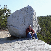
Outcrop of Lockport Dolostone commonly seen in the area
The shales underneath are much softer and more easily eroded. Here's a local example of similar differential erosion near Lockport, NY (Whirlpool Sandstone and Queenston Shale - see cross-section above).
Since the Lockport Dolostone is so hard and resistant, and is slightly tilted (dipping to the south), it doesn't weather as much as the surrounding shales and erodes to form a prominent cliff called the Niagara Escarpment.
The Niagara Escarpment runs over a large area from western New York, through Ontario, along the Upper Peninsula of Michigan, and then into Wisconsin (red line in map below).
We're only concerned with the escarpment where it crosses the Niagara River between Ontario, Canada and New York State (note the dipping Lockport layer).
The Great Lakes and Niagara River formed after the most recent Ice Age (the sequence of their formation is a bit complicated so I'll avoid that here). Basically, Niagara Falls formed at the Niagara Escarpment around 12,300 years ago and has been eroding upstream since then carving the Niagara Gorge through the Lockport Dolostone. The Dolostone ledge forms the resistant caprock to the falls (without this resistant rock unit, the Niagara River would descend from Lake Erie to Lake Ontario in a more gentle slope with no major waterfalls).
The American Falls pouring over the Niagara Escarpment
Since Niagara Falls is currently around 11.4 km (7.1 miles for those of us in the U.S.) from the Niagara Escarpment, and took 12,300 years to erode that far, how fast is the average rate of erosion here?
(7.1 mi / 12,300 yr) = 5.8 x 10⁻⁴ mi/yr x (5,280 ft / 1 mi) = 3 ft/yr
Three feet every year - that's pretty fast! The problem, of course, is that this is an average rate of erosion over 12,300 years. Why might this be a problem? How about an analogy...
If I got into my car and drove to Niagara Falls right now (350 mi), it might take me 6 hours. A reasonable assumption is that I took the New York State Thruway and traveled at 58 mph (350 mi / 6 hr). But maybe instead I drove at 70 mph for 5 hours and spent an hour leisurely eating dinner at a rest area. Or maybe I drove at 90 mph for 1 hour, got pulled over for a ticket for a half hour, and then drove 58 mph the rest of the way paranoid about getting another ticket. Average rates don't always tell us specifically what was going on during each moment of time.
So, what was going on during the past 12,300 years? Was Niagara Falls eroding at a constant rate the whole time or has the rate varied? We'll examine that in my next post.


No comments:
Post a Comment