Day 2 brings us to Columbia, Missouri for the night. For a geologist, there wasn't much to see between Columbus, OH, Indianapolis, IN, Effingham, IL, St Louis, MO, and Columbia along I-70. A few small peeks of limestone on the side of the road here and there.
In Indiana, we passed a squall line with a brief heavy downpour. These lines of thunderstorms are very common in the spring and summer months in the Midwest. They form when colder, drier air comes down from Canada (continental polar air masses - cP) meeting the warmer, moister air moving north from the Gulf of Mexico (maritime tropical air mass - mT). To facts about air play into this story - the first is that cold air is more dense than warm air (that's why hot air balloons rise - the hot air in the balloon is less dense than the surrounding air which gives it buoyancy) and the second is that there can be a lot of water vapor in warm air.
As the cold air mass moves southward and eastward (driven eastward by the west-to-east winds in the mid-latitudes), in meets the warm air mass along a relatively steep frontal boundary. The warm air is pushed up the frontal boundary and cools adiabatically (cooling which results from pressure change). As it cools, water vapor condenses to liquid water and you start piling up cumulonimbus clouds (thunderheads) which can develop heavy rainfalls and thunderstorms. If there's a big temperature contrast and lots of water vapor, you can even develop supercells and severe thunderstorms with hail and tornadoes.
Below is a typical squall line from radar imagery and the ground.
We saw the squall line pretty clearly ahead of us (IN is pretty flat, you can see for a good distance) but we drove through it in a matter of minutes. Fortunately, tomorrow we're passing through Kansas which looks pretty clear (last week there was a lot of tornadic activity in western Kansas).
We did make one stop today at the Cahokia Mounds. It's the second time we've been there but it's an interesting place. Between about 600 - 1,300 AD, it grew to become the largest city in what's now the U.S. with perhaps as many as 40,000 people (it wasn't until the 1800s that modern cities surpassed that number). In 1,250 AD, there were more people in Cahokia than in London, England (and Cahokia was probably a nicer place to live for the average person of the time).
The Native Americans living there at the time traded for copper from Michigan, seashells from the Gulf of Mexico, minerals from the Appalachians, and perhaps even had contact with the Anasazi of the American Southwest. It was an amazing place during its heyday.
Right next to a present-day highway is Monk's Mound, a 10-story earthen pyramid. It was once topped by a building housing the ruler of the city and is aligned with the N-S-E-W directions. From the top you can see the Mississippi and St. Louis Gateway Arch in the distance.
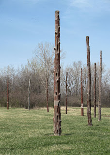
Lots of other mounds dot the landscape. Nearby is a reconstruction of Woodhenge, a circular structure of poles marking the solstice and equinox sunrises and may have served other calendrical purposes (as well as certainly being of ceremonial importance).
The Cahokia Mounds visitor's center is a neat place to visit and contains many of the excavated tools and artifacts from the site as well as artistic reconstructions of life in the once-great American city of 1,000 years ago. Decline around 1,300 AD may have been due to a number of factors - disease from the south brought into the area by the Conquistadors of Spain, climate change leading to widespread drought, warfare, or other reasons unknown to us today.
After Cahokia, it's neat to pass over the Mississippi at St Louis and drive past the Gateway Arch. I always feel I'm finally in the west after passing that landmark (even though much of Missouri resembles upstate New York).
Wednesday, June 2, 2010
Subscribe to:
Post Comments (Atom)


No comments:
Post a Comment