
Thursday, July 4, 2013

Fireworks - Chemistry & Physics

It's the fourth of July and everyone loves a good fireworks show.  Lots of chemistry and physics (and even some geology) behind these awe-inspiring shows of hot summer evenings.


To launch of fireworks shell, you first have to light the fuse.  Fuses for fireworks are generally formed from cords with a black powder core.  They burn at a controlled rate and are used to ignite the shell's slow-burning black powder propellant - a combination of 75% saltpeter (potassium nitrate or KNO3), 15% charcoal (basically C), and 10% sulfur (S).

Black powder has been around a long time and was invented back in 7th century China.  It's a "low" explosive that burns at slower subsonic speeds rather than the fast detonation of  "high" explosives making it ideal as a propellant.  The charcoal in black powder acts as a fuel, the sulfur increases the rate of combustion by lowering the temperature of ignition of the mixture, and the saltpeter breaks down to provide the oxygen necessary for combustion (4KNO3 → 2K2O + 2N2 +  5O2).
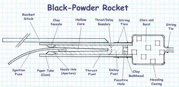
Professional fireworks are launched out of mortars
unlike bottle rockets which use sticks as shown above

As the shell ascends, a time-delay fuse is still burning toward the upper compartment of the shell where the "stars" are located.  The stars are 3-4 mm clay-like masses which contain the chemicals necessary for the pyrotechnics show when the shell explodes from its charge of high explosives.  It's all a matter of timing.  You want the fireworks to explode at the apex of the shell's climb.

A 6" fireworks shell.  Fuse is at left, black cubes are the "stars",
a gray explosive charge is to the right, and the black powder
propellant is at the far right.  All encased in a cardboard shell.

Setting up the mortars and shells for a show

The high explosive charge ignites the stars and tosses them outward.  The packing of the explosive and the stars determines the type of effect- the spherical peony or chrysanthemum, the expanding ring, the drooping willow, etc.

 
There's a whole art and science behind the packing of fireworks shells with different configurations, formulations, and shapes.
 

Colors, of course, are due to the chemical composition of the stars.  Reds are formed from strontium (SrCO3) or lithium carbonates (Li2CO3), orange from calcium chloride (CaCl2), yellow from sodium chloride (NaCl), green from barium chloride (BaCl2), blue from copper chloride (CuCl), etc.  Every manufacturer has their own secret formulations.

The explosive boom heard when watching a fireworks display is caused by the high explosive charge pushing air outward at faster than the speed of sound (340 m/s) causing a sonic boom. There is a noticeable delay between seeing the explosion and hearing the explosion since light travels much faster at 300,000,000 m/s (almost a million times faster!).  There's a 3 second delay between the flash and the boom for every kilometer of distance you are from the exploding shell.

Another funny thing about fireworks is that they appear to be two-dimensional, like they're being displayed on a flat screen, unless you're right underneath them.  This is because your eyes and brain can't determine which way the burning fragments of stars are moving since they're so bright against a black background.

You've seen the chemistry and physics, where does the geology come in?  Over 2/3 of the world's strontium, for example, comes from China where the strontium sulfate (SrSO4) mineral celestine, also known as celestite, is mined.  Barium comes from the barium sulfate (BaSO4) mineral barite.  Lithium comes from minerals like spodumene, a lithium aluminum silicate - LiAl(SiO3)2.  People tend to forget that virtually all the chemical elements we use in our modern industrial society have, as their origin, minerals dug from the Earth.

Science, as always, enhances our appreciation of beauty by giving us a deeper understanding of what we see and experience and how everything is connected in the world around us.


Enjoy the show and Happy Independence Day 2013!

Wednesday, July 3, 2013

Hyde Park Mastodon (in Ithaca)

In  1999, the Lozier family in Hyde Park, New York wanted to enlarge a small pond in their backyard off Haviland Road. 

 
They hired a backhoe to dig it out some muck and stumbled upon an amazing find - the humerus  (upper forelimb) of a mastodon.  Too big to be a horse or cow bone, the family showed the bone around, made some phone calls, and generally met with skepticism.  As Larry Lozier recalled:

"Nobody believed me," he said. "They thought some guy from Hyde Park found a cow bone and thinks it's a dinosaur."


Eventually Lozier got an archaeology professor from Bard College interested in taking a look.  The bone was recognized as belonging to a mastodon and things moved quickly from that point.  Media coverage followed and in the late summer of 2000, paleontologists from Ithaca's Paleontological Research Institute pumped the pond and began professionally excavating the find.


The excavation was done with the help of a lot of volunteers from local colleges (except where I teach, no one told us about it since we're just a lowly community college).  It was muddy work as the pond was spring fed and constant pumping was required.


It was an amazing find with 95% of the bones recovered including the important skull, both tusks, and all the major limb bones.  It was an older male (30-40 years old) specimen of an American mastodon (Mammut americanum).  He weighed anywhere from 10,000 -15,000 pounds (4,500 - 6,800 kg) when alive and stood about 9 feet tall at his shoulder.


Overview of the site

The 1999-2000 academic year was my first year teaching in the area and, as I said, our college was out of the loop, so I didn't find out about the Hyde Park mastodon it until I read about the excavation in a local newspaper.  I drove over to visit the site, met the family and some volunteers who were very friendly, and was fortunate enough to be able to go down into the pit, collect some of the muck (more about that in a bit), and see some bones (the skull was already crated).

Decade old version of me with a femur

The upside-down crated skull

Spruce log in the pit

Another shot of some limb bones

The "muck" containing small freshwater invertebrate shells

The mastodon (and the spruce log above) were radiocarbon dated to 11,500 years old.  This is the end of the great Pleistocene Ice Age when the glaciers were retreating up the Hudson Valley and this area was changing from tundra to conifer forest (hence the spruce log).  The mastodon was walking through the area, perhaps over a frozen pond where he fell through the ice where he drowned.  Buried by sediments, soft tissues rotted away, but his bones were preserved to the present day.

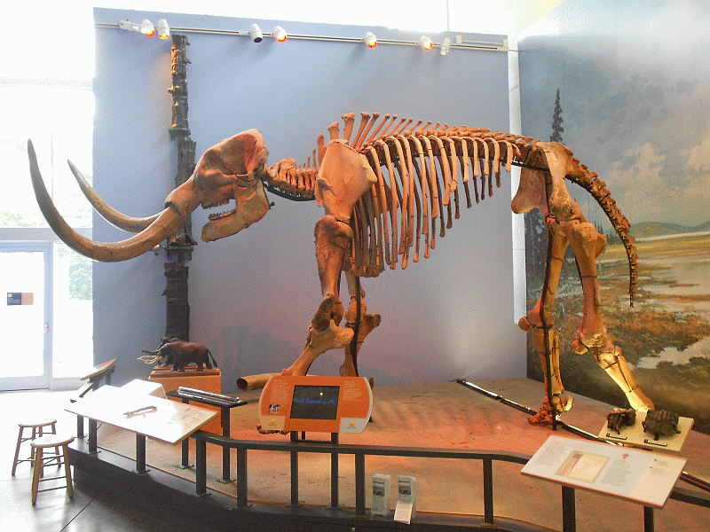
Last week, my family and some friends spent a couple of days at Watkins Glen.  We also made a side trip to the wonderful Museum of the Earth in nearby Ithaca (HIGHLY recommended!).  Guess what's there?  The Hyde Park mastodon in all its reconstructed glory!

Side view
 
Front view (pretty impressive tusks!)
 
 Skull
 
It wasn't that long ago (a geologic instant of time) that these guys were tromping around in our backyards here in the Hudson Valley.
 
 
The Discovery Channel did a neat show called Mastodon in Your Backyard on the find.  Here's an excerpt you can watch online (I have a copy of the VHS video, but don't think it's sold anymore - it may be in local public libraries).
 
By the way, mammoths and mastodons are two different groups of animals.  They both, along with modern African and Asiatic elephants, belong to the mammalian order of Proboscidea.  Mastodons (family Mammutidae, genus Mammut) split off from this line around 27 million years ago (Oligocene Epoch) while mammoths (family Elephantidae, genus Mammuthus) split off only around 5 million years ago (Pliocene Epoch) just before the Pleistocene ice age.  Mammoths, being in the same taxonomic family, are more closely related to modern elephants.
 
While most, but not all, species of mammoths were larger than mastodons, and often had longer tusks, the real difference between the these two extinct beasts were in their teeth.  The picture below shows someone holding a mastodon tooth on the left and a mammoth tooth on the right.

 
The word mastodon literally means "breast tooth" due to the nipple-like bumps on their molars (at least as seen by French anatomist Georges Cuvier in 1806).  Their teeth were adapted for browsing - eating shrubs, leaves, grass, whatever.  Mammoth teeth, on the other hand, are long and flat with ridges.  Their teeth were adapted for grazing on grasses.
 
A final aside... You may also see the alternative spelling of mastodont with a "t".  Technically, it's supposedly more correct with the "t" given it's derivation from Greek roots (an orthodontist, for example, puts braces on your teeth to make them straight) but you'll see both spellings routinely used.

Tuesday, July 2, 2013

Watkins Glen Flood of 1935

In my previous post, I discussed the geology of Watkins Glen.  Today I'd like to say a few words about the flood of 1935 which greatly affected this area.

In July 7-8, 1935, a slow-moving low pressure system stalled along a cold front in central New York, merged with a system which had moved up the coast, and then intensified.  A number of  thunderstorms described as "extraordinarily severe" by those living in the area dumped nearly a foot of rain within 48 hours in a band just south of the Finger Lakes causing massive flooding in the Southern Tier (the "Finger Lakes Flood"). 

As one eyewitness described the storm: "After a week of good weather, thunder storms were forecast for the afternoon of Sunday, the 7th. They arrived about 4:00 p.m. and the water came down harder than I had ever seen it rain before, or I have since that deluge."

Major flooding occurred along many rivers and streams in the area inundating towns and cities throughout the Southern Tier and Finger Lakes Region.

Hydrograph of Southern Tier Rivers (1935)

As it does today, a railroad bridge ran over the upper part of Watkins Glen and a trestle was in the middle of Glen Creek.  Floodwaters lodged debris against the trestle, water dammed up behind it and eventually the trestle itself broke away and washed downstream with a massive wall of water.

Railroad trestle over Glen Creek after the flood

The water roared down the Glen, emerged, and then ripped through the village of Watkins Glen causing widespread destruction.

Scene from the village of Watkins Glen in July, 1935

I couldn't find any pictures from the inside of the Glen, but the entrance area clearly showed major damage after the flood.

Pre-flood (above) and post-flood (below) pictures of the entrance to the Glen.
Note the stripped vegetation, railings missing from arched bridge, and washed away stairs.
 
Prior to the flood, much of the trail through the Glen was composed of wooden stairways and walkways.  After the flood, the Civilian Conservation Corps did much of the stone and masonry work seen on the beautiful walk through the Glen seen today.
 
 
While the flood was a tragedy for the people living in the area at the time, these types of events are completely normal over time spans of decades or centuries and are a part of the natural forces shaping the Glen.  While slow and gradual erosion occurs 24 hours a day, 7 days a week, 365 days a year as the stream flows down through the gorge with its normal load of abrasive sediments, every once in a while a flood, and sometimes a massive flood, occurs causing a great deal of erosion in a very short period of time.
 
As the geologist Derek Ager once famously said: "...the history of any one part of the earth, like the life of a soldier, consists of long periods of boredom and short periods of terror."
 
Floods are not freak events.  They're a normal part of the natural geologic cycle.

Monday, July 1, 2013

Watkins Glen

It's been a while since I posted but, as usual, things have been busy.  I don't get pay, recognition, or much else for writing a blog - it's mostly for my own benefit and to encourage my writing.  If others find it interesting or useful, that's an extra benefit!

Anyway, a few days ago, my family and I, along with another family, spend a couple of days at Watkins Glen (camping in the State Park - yes, it was raining much of the time).  The town of Watkins Glen is located at the southern end of Seneca Lake, the largest of the Finger Lakes in central New York.  While many people may associate the town with NASCAR racing (sorry, simply don't see the appeal), its most interesting feature is a stream-carved gorge now preserved as a State Park.

I'm in the beige rain jacket.  My wife has the white sneakers.

The gorge was certainly known to the native Seneca Indians but its name comes from Dr. Samuel Watkins and his brother John who acquired land in the area in the 1850s (the town was named "Watkins" in 1854 after John's death).  In 1863, the Glen was opened to the public as a privately-run tourist operation until it was purchased by the State in 1906 and it became a state park in 1924.  The word "Glen" was also added to town name of "Watkins" in the mid-1920s, capitalizing on the tourist appeal of the area.

Satellite image of Finger Lakes (Lake Ontario at top).  Small red
dot at southern end of Seneca Lake indicates the town of Watkins Glen.

A beautiful trail with 800+ steps runs 1.5 miles and 500 feet of elevation gain through the Glen and I highly recommend a visit if you're in the area.


As a geologist, I appreciate such places on two levels.  On one level, like everyone else, I enjoy the unique scenic beauty of the area.  But, since I'm fortunate enough to be a geologist, I also see and appreciate a lot of other aspects of the Glen that most people may never notice (of course, a botanist would notice all the plants or an entomologist insects - things I might be oblivious too as I walk around the world).

Anyway, let's talk a bit about the geology of Watkins Glen.  The geologic story of the Glen took place in two acts, each separated by almost 400 million years of time.  It all started during a time geologists call the Late Devonian Period (Frasnian Age), some 375 million years ago.

The world was very different back then.  Below is a paleogeographic reconstruction of North America during that time.  The equator, and the direction of north, is shown.  State outlines give an idea of where things are today.

Reconstruction from Ron Blakey, NAU Geology

Let's look at a close-up of New York State.


The red dot denotes the Finger Lakes Region of central New York.  It was under shallow seawater during this time in a subtropical climate zone just south of the equator.  In eastern New York into New England there was a mountain belt which geologists call the Acadian Mountains.  They resulted from the collision of a small microcontinent (which is now permanently attached as New England) with proto-North America.  Just as India colliding with Asia in more recent times thrust up the Himalaya, the collision of Avalonia (the microcontinent's name) with Laurentia (what geologists call proto-North America) formed the Himalayan-sized Acadian Mountains.

As these mountains eroded, the sediments were washed westward into that shallow sea.  Over time, land built outward in a large wedge called the Catskill Delta.  The horizontally-bedded conglomerates, sandstones, and shales of the present-day Catskill Mountains and Allegheny Plateau to the west were formed from these sediments shed from the Acadian Mountains.

From The Earth Through Time by Levin

We know these sedimentary rocks in the Watkins Glen area were formed from sediments deposited underwater because they contain various types of marine fossils.

Clam fossils from the Finger Lakes Region

Some of the sandstone layers in Watkins Glen also have ripple marks preserved.  These are the same types of ripples one sees today under shallow marine water in sands (I got very excited to see the ones below on the main trail through the Glen).

Symmetrical ripple marks on the rock walkway.

Over tens of millions of years, sediments accumulated in this environment and were buried deep enough for the soft sediments to be lithified into sedimentary rock (and preserve the remains of ripples and ancient seafloor organisms as fossils).

The next part of the story of Watkins Glen is more recent.  These once-buried rocks were eventually brought back to the surface by erosion of overlying rocks and sediments.  When buried, these rocks were under pressure.  When brought to the surface, pressure was released and they expanded.  When expanding, two sets of fractures developed from the tensile (pulling apart) stresses forming what geologists call an orthogonal joint set (fracture sets at right angles to each other).  These are easy to see in the cliff walls of the Glen.

Joints in the cliff wall of the gorge.
In this area, the joints are generally oriented ENE-NNW.  When rock is eroded by flowing water or glacial ice, the joint directions are preferentially carved out because the rock is weaker in those directions.  Let's look at a terrain map of the area showing topography.
Google maps view of Watkins Glen area

Note that Seneca Lake is oriented NNW and Watkins Glen is oriented ENE at right angles.  That's not a coincidence.  They were preferentially carved along the regional orthogonal joint sets.  Most people probably know that the Finger Lakes were carved during the last ice age during the Pleistocene Epoch of geologic time (2 million to about 10,000 years ago).

Let's imagine what this area looked like 10,000 years ago as the great glacial ice sheets melted away.  Seneca Lake was a deep glacial trough (close to 600 feet deep at its deepest) filling with glacial meltwater.  Glen Creek flowed into the deep trough from higher elevations to the west as a hanging valley (perhaps a spectacular waterfall at some point).  Over the past 10,000 years, Glen Creek has been cutting down into the horizontal layers of sandstones and shales resulting in a deep gorge with stepped waterfalls, scalloped walls, and potholes - Watkins Glen.

Stepped waterfalls (and a side tributary)

Scalloped walls and potholes of the Glen

Tomorrow, I'll post a brief story of the 1935 flood which devastated this region.