Saturday, April 20, 2024

New Jersey Earthquake (Part III)

In Part I of this post, I introduced the recent (April 5) New Jersey earthquake felt here in the Hudson Valley. In Part II, I talked a little about the geologic setting. Let's now finish up by discussing the Ramapo Fault.

As I mentioned in the last post, the Ramapo Fault or, more accurately, the Ramapo Fault System since it's not just a single fault trace is the western boundary of the Newark Basin - a rift valley that opened up when the supercontinent of Pangaea broke apart starting some 200 million years ago. On the east side of the fault are the Hudson Highlands of New York and the New Jersey Highlands to the south - the rocks that formed deep in the Grenville mountain belt over a billion years ago.

This fault has been around a long time with its major activity occurring during the time of the dinosaurs as Pangaea rifted apart. Afterwards, it settled into a long period of quiescence only occasionally readjusting.

These types of earthquakes are called intraplate earthquakes because they occur in the interior of continental plates far from plate boundaries (in this case, the center of the Atlantic Ocean at the Mid-Atlantic Ridge). Why do they occur? Because movements of the tectonic plates at their boundaries cause stresses that can be transmitted long distances into the middle of the rigid tectonic plates. The old faults, formed hundreds of millions of years ago, may be oriented such that those stresses just happen to be enough to trigger their movement.

Intraplate earthquakes do occur in places like New Jersey. Below is a map of earthquakes from the late 1700s until recent. While most intraplate earthquakes are barely felt, they may also reach moderate levels and, in rare cases, become strong. This typically causes more damage in places like the Northeast where we don't routinely build to earthquake standards as the do in California.

If you want to worry, Google the 1886 Charleston, SC earthquake or the 1811-1812 New Madrid, MO earthquakes. Areas which show up very nicely on this seismic hazard map of the U.S.
Sunday, April 7, 2024

New Jersey Earthquake (Part II)

In Part I of this post, I introduced the recent (April 5) New Jersey earthquake felt here in the Hudson Valley. Let's now talk a little about the geology.

The east coast of the U.S. has a long history stretching back almost 1.5 billion years (compared to the 4.5 billion year history of the Earth as a whole). During that time, our area experienced four major mountain-building events (which geologists call orogenies from the Greek work for mountain - oros). These mountain building events were due to collisions of crust from plate tectonic movement. Most of those mountains have since weathered away leaving remnants of rock that formed miles below the surface. There were also two major rifting events in that time period as blocks of crust pulled away again after those collisions (sometimes they also stuck around!).

All of these collisions and rifting events left folded rocks and faults. Many people are under the mistaken impression that faults only occur out west but there are faults you can see in rock outcrops on the side of the road anywhere in the Hudson Valley. But, unlike those currently active faults out west (like the infamous San Andreas), most of the faults here in our area formed hundreds of millions of years ago and have been inactive for a long time. But, as we'll see, sometimes they can be reactivated.

Most active faults are found near tectonic plate boundaries. The San Andreas, for example, is basically the plate boundary between the North American Plate and the Pacific Plate.


Here on the east coast, however, we're a couple thousand miles from the nearest plate boundary which is in the middle of the Atlantic Ocean at the Mid-Atlantic Ridge which separates the North American Plate from the Eurasian and African Plates. However, as tectonics plates jostle each other at the plate boundaries, stresses are transmitted into the interior of the rigid plates. These stresses can sometimes trigger preexisting fault movement to form what are called intraplate earthquakes (earthquakes in the middle of a tectonic plate).

Typically, these intraplate earthquakes aren't very large, but occasionally moderate ones can occur and very occasionally large ones (look up the 1811/1812 New Madrid, MO or the 1886 Charleston, SC quakes).

OK, so now let's look at New Jersey. New Jersey is made up of several physiographic provinces.

As you can see, the boundary between the Highlands and the Piedmont regions is a fault called the Ramapo Fault.

The NJ Highlands region extends northeastward in the Hudson Highlands of New York and represents rocks that formed miles below an ancient Himalayan-scale mountain belt formed during an event called the Grenville Orogeny over a billion years ago.

The Piedmont region is underlain by sedimentary rock intruded by igneous lava flows forming linear ridges. These formed when the supercontinent of Pangaea began rifting apart around 200 million years ago. This formed what's called the Newark Basin or Newark Rift (which extends upwards into Rockland County, NY).

The boundary between the Highlands and the Newark Basin (Piedmont) is a major fault which formed at that time - the Ramapo Fault. In the diagram below, the grays, yellows, and reds represent sedimentary rocks which filled the Newark Basin as it was pulling apart and rifting while the black colors represent the igneous intrusions of magma and lava flows (the most famous being the Palisades Sill along the Hudson River). The NJ Highlands are off to the left (west) of this diagram in orange (the same rocks also underlie the basin).

I will pick this up in Part III in a day or two.

Saturday, April 6, 2024

New Jersey Earthquake (Part I)

So I was in my office yesterday morning (Friday, April 5), engrossed in proofreading an important document going out to our college's accrediting agency, when I vaguely felt something. My colleague, in the adjacent office said "Was that an earthquake?" and I first thought maybe it was someone working on the roof (which they've been doing a lot lately) or it was a strong wind gust (but looking out the window showed everything calm). I pulled up the National Earthquake Information Center and, low and behold, a magnitude 4.8 earthquake in northwestern NJ popped up. So I guess I did feel it, but didn't recognize it as an earthquake at the moment. Same is true for a lot of other people I talked to at the college.

As a geologist, a moderate earthquake in New Jersey doesn't overly surprise me. While not common, they do occur. A few aftershocks have also occurred, the strongest a 4.0.


Here's a picture you can find in a lot of geology textbooks. It illustrates, using the Virginia 5.8 earthquake in 2011 (also felt in the Hudson Valley) how east coast earthquakes are felt over a much larger area than west coast earthquakes of the same magnitude.

This difference is due to the fact that rocks in the east are older, colder, and more intact than rocks in the west. Out west, the rocks are much more fragmented by faults and these faults attenuate (weaken) the energy from earthquakes. Here's a map of felt shaking from the New Jersey quake.

So how often do earthquakes occur in New Jersey? Here's a nice map.

I will continue this discussion in a second post in a day or two...

Sunday, March 3, 2024

Giant Beavers!

Did you know there were once giant beavers roaming the Hudson Valley region?

Bear-sized giant beavers (Castoroides ohioensis) lived during the Pleistocene Epoch (the time of the most recent ice age) and grew to over 7 feet in length with a weight of over 200 pounds. As their scientific name implies, they were first discovered in Ohio (1837) but extended from the upper Midwest and Canada over to the east coast (another species - Castoroides dilophidus - existed in the southeastern U.S.).

Giant beavers did exist in the Hudson Valley. One, for example, was discovered (along with caribou and flat-headed peccary fossils) at the Dutchess Quarry Cave site near Middletown in Orange County (near where a lot of mastodons have also been discovered). At this site, the beaver radiocarbon dated to 11,670 +/-70 years before present.

Castoroides ohioensis skeleton in the Field Museum, Chicago

Here's an artist's conception by the famous early 20th century illustrator Charles R. Knight.


The giant beaver differed from modern beavers in that they probably had rounded tails and not the flattened ones seen today and also in their teeth. Their teeth were much longer (up to 6 inches) and were ridged unlike the smooth teeth of modern beavers. These ridges would have strengthened their teeth and their jaw structure suggests that they would have had a strong biting force. It's hard to say if they constructed dams and lodges as beavers do today and stable isotope evidence from their bones indicates a mostly aquatic plant diet. Their large teeth were likely better adapted to digging in pond muck than in cutting trees.

Giant beavers first appear in the fossil record near the start of the Pleistocene ice age almost 2 million years ago and died out around 11,000 years ago as the North American climate was warming and glaciers had retreated north. The end of their time also overlapped with the migration of paleo-Indians into eastern North America. Did they die off due to climate change or did humans kill them off? This is the perennial question of all the Pleistocene megafauna which vanished around the same time.

While there is no direct evidence these early Native Americans hunted giant beavers (although it seems unlikely they would not have utilized all food source animals) some of the tribes have stories and legends that seem to be about them (it's amazing to think about oral traditions lasting thousands of years). They feature in an eastern Cree creation story and in tales by the Chippewa, Seneca, and other tribes (see, for example, https://www.jstor.org/stable/481746).

The Hudson Valley was a very different place just a few thousand years ago!

Monday, February 26, 2024

Learning from the past

There was a recent paper in Science Advances that’s gotten a lot of press lately. It discusses the possible collapse of the Atlantic meridional overturning circulation (AMOC) due to warming from climate change. This is not a new idea, here’s a July 2023 paper in Nature Communications saying the same thing (and forecasting a timeline between 2025 and the end of the century).

Basically, colder and more saline ocean water is more dense than warmer and less saline ocean water and these density differences lead to the development of areas of sinking water which drive deep currents (called thermohaline currents). These thermohaline currents are effectively mixing oceanic waters around the globe and hugely important in global climate.

In the AMOC, the Gulf Stream and North Atlantic Current bring warmer waters from the equatorial regions northward. At higher latitudes, this now colder water sinks down to drive deep thermohaline currents circulating water back south. If global temperatures continue to warm, the melting Greenland ice cap will dump enough freshwater into the North Atlantic to potentially disrupt the AMOC. This will have profound climatic implications for all of us.

Geologists, who have a longer view of things, know that the AMOC hasn’t always existed and there have been times during the last ice age when it has repeatedly collapsed and restarted. One of those times it collapsed may be tied to events right here in the Hudson Valley.

Some papers have suggested that a time known as the Intra-Allerød cold period that began around 13,360 years before present (B.P.) was due to temporary collapse of the AMOC. As the mighty continental glaciers melted back into Canada around 13,400 B.P., large amounts of meltwater were flowing south down through the Hudson Valley. Glacial moraines (ridges of glacial sediment called till) formed dams down by the Hudson Highlands formed a large freshwater lake called Lake Albany. Lake Albany was over 150 miles long and over 200 feet deep in places.


Also dammed up was what’s now Lake Ontario. It was much larger at this time and called Lake Iroquois (misspelled in the diagram below). Eventually Lake Iroquois broke through the dam and massive amounts of meltwater raced down the Hudson Valley and into the Atlantic Ocean (the whole story is a bit more complicated but you get the picture). There is evidence for this event both in the sediments of the Hudson Valley as well as features on the continental shelf seafloor out from the mouth of the Hudson River.

 The hypothesis is that this massive influx of freshwater disrupted the AMOC and led to a cooling period known in paleoclimatology as the Intra-Allerød cold period. It’s not fully accepted due to difficulties in getting exact dates and correlations for events occurring thousands of year ago, but certainly an intriguing hypothesis and perhaps indicative of events going on in the present day with the Greenland ice cap.

 It also shows how the study of geology can help us understand events occurring in the modern day.

Sunday, February 18, 2024

New Plates

 Just a short post today...

The Hudson Valley Geologist's wife bought me new customized license plates for Valentine's Day. I love them!


Sunday, February 11, 2024

Obsidian

If you frequent certain areas of social media, or visit new age mineral shops, you may have seen stuff touted as obsidian that is nothing but colored glass.

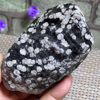
Real obsidian is volcanic glass. It's formed from volcanic eruptions when lava (molten rock) cools so quickly minerals don't have time to nucleate and grow. Most obsidian is black and glassy with distinctive conchoidal fracture.


Conchoidal fracture can be seen in the sample above and is the curved, shell-like way obsidian (and other glass) breaks leaving sharp edges. Native people around the world took advantage of this fracture pattern to use obsidian to make knives and spear tips.

Some obsidian has inclusions of a white mineral called cristobalite (a form of quartz) leading it to be called snowflake obsidian which is very pretty when tumbled or carved.


Mahogany obsidian has a brown coloration from some trapped iron oxide in the rock.


There are also some rare varieties of obsidian (sheen, rainbow, or fire obsidian) that show a metallic sheen or colorful iridescence. This is usually from microscopic gas bubbles or different mineral inclusions that reflect various wavelengths of light.


When visiting metaphysical shops that sell crystals, as I'm wont to do out of curiosity (I usually don't buy from them because I can go to rock and mineral shows and buy genuine samples at a fraction of the price), I have started seeing a lot of colored glass being sold as "obsidian". Here are some examples from Etsy.


While marketed as obsidian, and sometimes priced at hundreds of dollars, these are really just hunks of colored glass. They're usually formed as a by-product of steel manufacturing and found in industrial dumps. One variety that I know of is artificially manufactured from Mt St Helens ash (Helenite) and sold as natural. It about as natural as your kitchen window.

These are often marketed as Andara crystal, blue, green, or red obsidian, Gaia obsidian, Aqua Lemuria, and other made-up names with sometimes outrageous magical claims associated. Break a green beer bottle if you want some green glass - it will have about the same healing energy as these "crystals" and you can drink the beer beforehand.

Sunday, February 4, 2024

Wallace Creek and the San Andreas Fault

 This post is about an area a little far afield from the Hudson Valley but about a geologically significant area - it's featured in the lab manual I use for my Physical Geology course at SUNY Ulster.  It's about a place I visited on vacation a couple of years ago.

Wallace Creek is on the Carizzo Plain halfway between Los Angeles and San Francisco, east of the Coast Range, and in a dry, arid desert environment. I drove 7 miles or so down a dirt road to get there. (why I own an all-wheel drive vehicle with high clearance!).

What makes Wallace Creek so interesting is that it crosses the San Andreas Fault - the boundary between the North American tectonic plate and the Pacific tectonic plate. The Pacific Plate is trying to move northwards with respect to the North American Plate and, after stresses build up for a while, it eventually slips along one segment or another generating an earthquake (sometimes a large one).

On January 9, 1857, this segment of the fault actually moved 6 meters (20 feet or so) during the 7.9 magnitude Fort Tejon earthquake. As the fault moves over the years (centuries), the creek has become offset where it crosses the fault clearly showing the direction and magnitude of movement.

Here's a nice aerial view of the offset.

This view is looking south. On the left is the North American Plate and on the right is the Pacific Plate. You can clearly see the offset of Wallace Creek in the center of the photo with the Pacific Plate moving north (toward the bottom of the photo). The fault scarp of the San Andreas is clearly visible.

What's it look like on the ground? Below is the interpretive sign at the parking area.

Here's a look back to the parking area (two black dots) from the creek. My wife and stepson stayed in the car with the AC running because it was around 100 degrees F (the Hudson Valley Geologist is made of sterner stuff and will suffer for geology). The white in the distance is a soda (alkaline) lake bed. The path to the left follows the fault scarp of the San Andreas Fault.

The feature is a bit difficult to see from a ground picture, but the creek is running away from me here (it's dry but marked by the greenery in the ditch). In the distance it bends left (onto the Pacific Plate) and in the foreground where I'm standing it turns right onto the North American Plate (off the picture). Looking straight ahead (north) is looking along the axis of the San Andreas Plate.

After visiting Wallace Creek, we stopped at the Parkfield-Coalinga Bridge across Little Cholame Creek for a photo op. The bridge literally crosses the San Andreas Fault.

 I was so excited I couldn't resist a little pole dancing here (I'll keep by day job).

Sunday, January 28, 2024

Cohoes Mastodon

 If you visit the New York State Museum in Albany, you will see the Cohoes Mastodon.

The mastodon was discovered in September, 1866 during the construction of Harmony Mill #3 (one of the largest cotton mills in the world) near Cohoes Falls on the Mohawk River. Here's the sign on North Mohawk Street, at the northwest end of the massive Harmony Mill building (now apartments).

The bones were found buried in a deep pothole at the base of the falls. The falls themselves can be viewed from the appropriately named Falls View Park in Cohoes.

The potholes formed during higher water flow just after the last ice age. As the glaciers still sat up in Canada, the massive volumes of fresh meltwater created Glacial Lake Iroquois where the smaller Lake Ontario sits today. This water ripped through the Mohawk Valley into the Hudson Valley with 100 times the water flow of today's river.

Based on growth rings in the mastodon's tusk, we can determine he was around 32 years old when he died some 13,000 years ago. He led a hard life, almost starving to death at 11 from a wound to his lower jaw (probably from the tusk of another mastodon) and dying at 32 from another tusk wound to the temple. Here's a neat video from Dr. Robert Feranec at the New York State Museum talking about the mastodon.

The Cohoes Mastodon display at the State Museum is well worth visiting with a lot of information presented about this mastodon and mastodons in general. Around the corner is also the famous mastodon diorama recreating a mother and baby mastodon in the mid-Hudson Valley with Storm King Mountain in the distance.

These were real animals literally walking around our backyards a few thousand years ago.

Sunday, January 21, 2024

Out of Place Geodes?

When you're a geology professor, people often bring you things to identify. Usually, it's something easy to figure out (especially if it's local) and sometimes you have to disappoint them (supposed meteorites that turn out to be slag, for example). Occasionally, however, you get something truly odd.

A faculty colleague recently showed me some rocks that were dug up by her kid and friends at the base of a tree in a suburban area near Cantine Field in Saugerties, NY. A half-dozen or so spherical rocks several inches in diameter. 


At first they almost looked like cement, rather than rock, but after cracking a few open, we were surprised to find they were geodes. Even more surprising, they were all slightly different.


The one on the left took several swings of a heavy sledge to bust open and you can see there's a vein of chalcedony/chert running through the middle. The middle one had nice quartz crystals in the center, and the right one had well-formed calcite crystals!


The one on the left was even more odd. It had some white crystals (shown) that fizzed with hydrochloric acid (which would normally indicate calcite) but then when I washed the rock, they started to get soft and dissolve (which calcite does not do). I'm not sure what they are.

So, how did a pile of geodes end up in Saugerties? I have no idea. The bedrock in the nearby area is the Devonian Onondaga Limestone. I've never seen natural geodes in the area. My only guess is that they were once dumped there by someone. Where did the geodes originally come from? No idea. It's a mystery.

Do any readers recognize where they might be originally from or how they might have gotten there? Let me know!

Sunday, January 14, 2024

Cobalt Red

I recently read an interesting book, Cobalt Red, about cobalt mining in the Congo (a country that has been cruelly exploited by the west for centuries). The Katanga Region of the Congo in Africa holds more cobalt than the rest of the planet combined (as well as a host of other metallic ore minerals).

Why does the Congo hold so much cobalt? It's complicated. Here's a paper with the details if you're up on your geochemistry. The bottom line is that around 4-5 million years ago (the Pliocene Epoch), near surface rocks were exposed to weathering under just the right pH conditions to form a mineral called heterogenite (CoOOH), an ore of cobalt. Being near the surface, in heavily weathered material, the mineral is relatively easy to mine by hand.

Why is cobalt important? It's critical for making the cathodes (positive terminals) of lithium-ion batteries (which are in everything from cell phones to Teslas). China, South Korea, and Japan produce almost 90% of the world's lithium-ion batteries and they all get their cobalt from the Congo.

While companies that use lithium-ion batteries like Apple, Samsung, and Tesla tout how socially responsible they are on their websites, the reality of cobalt mining in the Congo is that it's done under slave-like conditions by "artisanal miners" as young as 12 who work under horrific conditions destroying their health and the landscape for a pittance while consumers in the U.S. feel virtuous for being "green" and multinational companies make billions.


The author is a U.K. professor who's research specialty is modern slavery. He faced real dangers traveling through the Congo and visiting these mines since the government there and the primarily Chinese mine owners resort to violence and murder to keep the status quo. Reading the comments of the miners is heartbreaking - "Here it is better not to be born." It's a depressing but important read.

Sunday, January 7, 2024

What on Earth is a Urolite?

Every heard of a urolite? Me neither. What about a coprolite? I suspect more people have probably heard of these.

Coprolites are fossilized feces or poop. There's nothing disgusting about them, the material has been completely mineralized and it's no worse than handling a rock (although when I pass one around the geology lab, some students are very reluctant to even touch it). Here are a couple of samples I have in my lab (I don't know what animal left these coprolites).

Coprolites are ichnofossils or trace fossils in that they record a trace of an organism's activity (rather than a fossil of the organism itself). Paleontologists find coprolites useful since they can often provide information about the animal's digestive system and diet - below are microscopic views of coprolites from a scientific paper studying the diet of a group of herbivorous dinosaurs.

I happened to stumble on a paper recently that introduced me to urolites. Urolites are another type of ichnofossil that are formed from sediments disturbed by the urine stream of an animal (hence the "uro" part of the name). In the case of the paper I read, urine streams from early Cretaceous Period dinosaurs in Brazil. Here's a picture from the paper of some urolite examples.


and a drawing illustrating the concept.


The authors said these fossils compared well to similar features formed by modern ostrich urinating in sand. They also claimed that this is the first direct evidence of liquid waste elimination by dinosaurs.

While not the sexiest of fossils, it's always neat to see what we can see and learn by careful observation of the world around us.